1980s Maps of Macon County, Illinois
Explore 17 historic maps of Macon County from the 1980s. These maps offer a rare glimpse into what life looked like during the 1980s — showing old roads, neighborhoods, homes, and landmarks that have changed or disappeared over time.
Whether you're researching your family's past, planning a metal detecting trip, or studying how Macon County's landscape evolved across the 1980s, these high-resolution maps are a powerful tool for exploring the history of this region.
- Focus on a specific era: All maps on this page are from the 1980s, giving you a focused view of this time period.
- See what’s changed: Compare century-old streets, trails, and buildings to today's modern landscape using overlays and satellite layers.
- Research with precision: Use these maps for genealogy, historical research, land use analysis, or educational projects.
- View, download, or print: Maps are fully viewable online in high resolution, and can be downloaded or printed for your own records.
Start exploring Macon County's history through authentic maps from the 1980s. This is your window into the past.
Macon County, IL maps
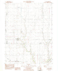
(17)- 1980 Map of Chestnut
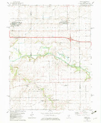
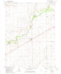 1980 Chestnut1980 Print · USGSThe rural landscape of central Illinois is captured here in the early 1980s, centered on the village of Chestnut. Family historians can locate numerous burial grounds like Donnan Cem and Hays Cem or trace the route of the Illinois Central Gulf railroad.
 - 1980 Map of Kenney, 1981 Print
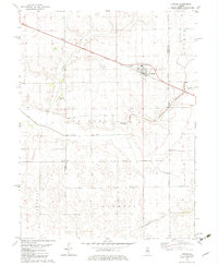
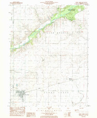
 1980 Kenney1981 Print · USGSRail-and-river life in De Witt County is frozen in time during the late twentieth century, centered on the village of Kenney. Researchers can locate several rural landmarks including Harmony Ch, Old Baptist Cem, and the small settlement of Rowell.
 - 1982 Map of Harristown, 1983 Print
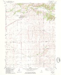
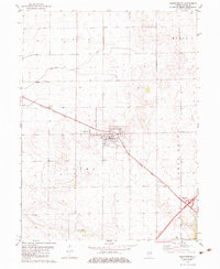
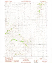
 1982 Harristown1983 Print · USGSMacon County's rural landscape and the western expansion of Decatur are captured here in the early eighties. Genealogists and historians can trace family-named landmarks like Crum Cem and Whitley Cem alongside the winding Sangamon River.
 - 1982 Map of Stonington, 1983 Print
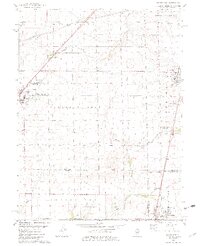
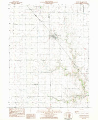
 1982 Stonington1983 Print · USGSCentral Illinois agriculture and industry meet along the Christian-Macon county line in the early 1980s. Genealogists and local historians can trace the town of Stonington, locate Mt Zion Cem, and see the extent of the Mt Auburn Consolidated Oil Field.2 unique versions available
 - 1982 Map of Niantic, 1983 Print
 1982 Niantic1983 Print · USGSNiantic and Illiopolis sit at the heart of this early 1980s landscape, where the Sangamon River valley meets a bustling rail corridor. Researchers can locate generational sites like Hunter Cem, Long Point Ch, and the rural outpost of Osbernville.
 - 1982 Map of Latham, 1983 Print
 1982 Latham1983 Print · USGSThe village of Latham and the rail corridors of Central Illinois are captured here in the early eighties. Genealogists can locate family sites at Lake Bank Cem and Twomile Grove Cem or trace the path of the Illinois Central Gulf railroad.
 - 1982 Map of Warrensburg, 1983 Print
 1982 Warrensburg1983 Print · USGSWarrensburg and the surrounding townships of Illini and Austin are shown here in the early eighties as the railroad still anchored the local economy. Researchers can locate family landmarks like Illini Ch Cem, the Warrensburg-Latham Sch, and the small settlement of Bearsdale.
 - 1982 Map of Macon West, 1983 Print
 1982 Macon West1983 Print · USGSCentral Illinois farmlands in the early eighties show a landscape organized by rail corridors and quiet country churches. Genealogists can trace family plots at South Macon Cem, Adams Cem, or Traughber Cem and locate historic schools like the High Sch in Moweaqua.2 unique versions available
 - 1983 Map of La Place
 1983 La Place1983 Print · USGSThe grain-and-rail landscape of central Illinois is captured here in the early eighties. Genealogists and local historians can trace the foundations of LaPlace and Lake City, alongside rural landmarks like Turner Cem and Stringtown.
 - 1983 Map of Cerro Gordo
 1983 Cerro Gordo1983 Print · USGSThe Illinois prairie of the 1980s is captured here at the Macon and Piatt county line, where the Norfolk and Western rail line links rural communities. Genealogists can locate several family burial grounds, including Pioneer Cem and Willow Branch Cem, near the banks of the Sangamon River.
 - 1983 Map of Macon East
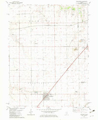
 1983 Macon East1983 Print · USGSMacon and the surrounding townships are captured in the early eighties as the rail-and-farm economy continued to shape the prairie. Trace local history at the Long Grove Cem, the Sanner Chapel, and the private Hilvety Airport.
 - 1983 Map of Dalton City
 1983 Dalton City1983 Print · USGSDalton City and its surrounding townships are shown here in the early eighties, centered on the vital grain-shipping corridor of the Illinois Central Gulf railroad. Researchers can locate family landmarks like New Hope Cem, the small settlement of Reddy, and Walker Cem.
 - 1985 Map of Decatur
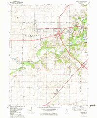
 1985 Decatur1985 Print · USGSCentral Illinois farming and rail hubs thrive in the mid-1980s as Decatur anchors a sprawling network of track and timber. Trace the paths of the Sangamon River and the Illinois Central Gulf RR through old towns like Cerro Gordo and Bement.2 unique versions available
 - 1985 Map of Lincoln
 1985 Lincoln1985 Print · USGSMid-century Illinois comes to life in this survey of Logan and Mason counties as the interstate era reshapes the prairie. Genealogists and historians can trace rail-town development from San Jose to Kenney or locate landmarks like Rose Hill Cem and Funks Grove.
 - 1985 Map of Springfield
 1985 Springfield1985 Print · USGSCentral Illinois during the mid-eighties shows a landscape of growing state capital influence and deep historical roots. Genealogists and historians can trace family sites near Oak Ridge Cem or follow the path of the Sangamon River past Williamsville and Riverton.2 unique versions available
 - 1985 Map of Champaign, 1986 Print
 1985 Champaign1986 Print · USGSThe Illinois prairie comes alive in this mid-eighties survey of the vital rail corridor between Bloomington and Champaign. Genealogists and historians can trace the development of township hubs like Saybrook and Bellflower or locate Chanute Air Force Base and the Sangamon River.2 unique versions available
 - 1989 Map of Lincoln
 1989 Lincoln1989 Print · USGSCentral Illinois in the late eighties remains a landscape of productive prairie and vital river arteries. Genealogists and local historians can trace rural family landmarks like Rose Hill Cem, identify early aviation at Logan County Airport, or follow the Illinois Central Gulf Railroad through towns like Atlanta and Lincoln.
End of results
Showing maps 1-17 of 17
Top cities of Macon County
- Decatur historical maps
- Mount Zion historical maps
- Forsyth historical maps
- Maroa historical maps
- Long Creek historical maps
- Harristown historical maps
See more
Frequently asked questions
- What are the different types of historical maps available for Macon County?
- What is the oldest map of Macon County?
- Where can I purchase historical maps of Macon County for my home or office?
- Where can I download high-res historical maps of Macon County?
- Are there historical topographic maps available for Macon County?
- Is there historical aerial imagery available for Macon County?
- Where are historical maps of Macon County sourced from?