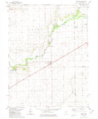
1980 Map of Chestnut
USGS Topo · Published 1980About this map
Chestnut sits at the junction of rail and road in central Illinois, serving as a hub for the agricultural townships of Aetna and Laenna. The Illinois Central Gulf railroad cuts a straight diagonal across the prairie, reflecting the transportation network that sustained these rural communities. The meandering path of Salt Creek provides a stark contrast to the rigid grid of the Third Principal Meridian, creating a landscape defined by both natural drainage and surveyor precision. Numerous family and community burial sites, including Harmony Cem, Randolph Cem, and Laenna Cem, are scattered across the quadrangle, offering significant touchpoints for genealogical research. Local recreation and history are centered around Old Settlers Park and Chestnut-Beason Park, while industrial activity is noted at several Gravel Pit locations along the creek.
Find a feature on this map
25 named features on this map. Tap any name to fly to it.
Don’t see what you’re looking for? This feature index may not catch every label — zoom into the map to look around manually.
Map Details
Editions of this 1980 Chestnut Map
This is the sole edition of this map. No revisions or reprints were ever made.
Other maps of this area

1911 · Lincoln
USGS Topo · 1:62,500

1913 · Lincoln
USGS Topo · 1:62,500

1954 · Niantic
USGS Topo · 1:62,500

1954 · Mechanicsburg
USGS Topo · 1:62,500

1957 · Kenney
USGS Topo · 1:62,500

1958 · Peoria
USGS Topo · 1:250,000

1958 · Decatur
USGS Topo · 1:250,000

1961 · Peoria
USGS Topo · 1:250,000

1961 · Decatur
USGS Topo · 1:250,000

1963 · Peoria
USGS Topo · 1:250,000