
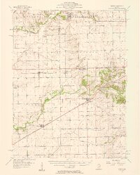
1957 Map of Kenney
USGS Topo · Published 1958About this map
Kenney and Chestnut stand as central hubs in this mid-century agricultural landscape, situated at the crossroads of the Illinois Central and Pennsylvania railroads. The map reveals a high density of rural institutions, with dozens of family and community burial grounds such as Pleasant Valley Cem and Tunbridge Cem dotting the countryside. The transition of rural education is evident in the marking of Mt Zion Sch and Upper Ridge Sch as abandoned, reflecting the consolidation of local school districts common during the 1950s.
Find a feature on this map
42 named features on this map. Tap any name to fly to it.
Don’t see what you’re looking for? This feature index may not catch every label — zoom into the map to look around manually.
Map Details
Editions of this 1957 Kenney Map
2 editions found
Other maps of this area

1911 · Lincoln
USGS Topo · 1:62,500

1913 · Lincoln
USGS Topo · 1:62,500

1929 · Decatur
USGS Topo · 1:62,500

1933 · Decatur
USGS Topo · 1:62,500

1949 · Mc Lean
USGS Topo · 1:62,500

1951 · McLean
USGS Topo · 1:62,500

1951 · Minier
USGS Topo · 1:62,500

1951 · Le Roy
USGS Topo · 1:62,500

1954 · Niantic
USGS Topo · 1:62,500

1954 · Mechanicsburg
USGS Topo · 1:62,500