1950s Maps of Macon County, Illinois
Explore 7 historic maps of Macon County from the 1950s. These maps offer a rare glimpse into what life looked like during the 1950s — showing old roads, neighborhoods, homes, and landmarks that have changed or disappeared over time.
Whether you're researching your family's past, planning a metal detecting trip, or studying how Macon County's landscape evolved across the 1950s, these high-resolution maps are a powerful tool for exploring the history of this region.
- Focus on a specific era: All maps on this page are from the 1950s, giving you a focused view of this time period.
- See what’s changed: Compare century-old streets, trails, and buildings to today's modern landscape using overlays and satellite layers.
- Research with precision: Use these maps for genealogy, historical research, land use analysis, or educational projects.
- View, download, or print: Maps are fully viewable online in high resolution, and can be downloaded or printed for your own records.
Start exploring Macon County's history through authentic maps from the 1950s. This is your window into the past.
Macon County, IL maps
(7)- 1952 Map of Assumption, 1953 Print
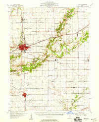
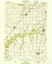 1952 Assumption1953 Print · USGSChristian and Macon counties are seen here in the early fifties, a time when rail lines like the Wabash and Illinois Central still connected small farming towns. Researchers can locate early family burial grounds such as Adams Cem or trace the development of the Mc Coy Airport.2 unique versions available
 - 1954 Map of Niantic, 1955 Print
 1954 Niantic1955 Print · USGSMid-century Macon County is defined here by its bustling rail corridors and the winding Sangamon River. Researchers can trace old family names at Lake Bank Cem or locate forgotten stops like Wyckles Corners and Bulldog Crossing.3 unique versions available
 - 1955 Map of Bement, 1956 Print
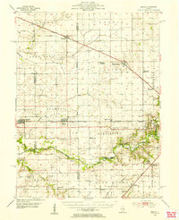
 1955 Bement1956 Print · USGSCentral Illinois prairie life revolved around rail junctions and rural townships in the mid-1950s. Genealogists can trace family footprints at Willow Branch Cem or Asbury Ch, while following the lines of the Wabash and Baltimore and Ohio railroads.2 unique versions available
 - 1957 Map of Kenney, 1958 Print
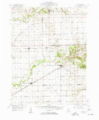 1957 Kenney1958 Print · USGSDe Witt and Logan Counties are captured in the late 1950s as the rail-and-river network shaped the prairie landscape. Genealogists can trace rural family plots at McClimans Cem or locate former landmarks like Mt Zion Sch.2 unique versions available
 - 1957 Map of Maroa, 1958 Print
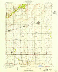
 1957 Maroa1958 Print · USGSCentral Illinois during the late fifties reveals a landscape of thriving rail towns and quiet rural outposts. Genealogists can trace family footprints at Crum Cem or Shiloh Ch, and locate vanished landmarks like Texas Sch.2 unique versions available
 - 1958 Map of Peoria, 1969 Print
 1958 Peoria1969 Print · USGSCentral Illinois thrived as a hub of education and transport during the late sixties, as the new interstate system began to reshape the prairie. Genealogists and historians can trace local landmarks like Springdale Cem, Bradley University, and the sprawling grounds of Chanute AFB.4 unique versions available
 - 1958 Map of Decatur, 1971 Print
 1958 Decatur1971 Print · USGSCentral Illinois in the mid-twentieth century shows a landscape defined by industrial rail hubs and the creation of large reservoirs. Researchers can trace historic corridors like the Penn Central or locate landmarks such as Lincoln Log Cabin State Park and Lake Springfield.3 unique versions available
End of results
Showing maps 1-7 of 7
Top cities of Macon County
- Decatur historical maps
- Mount Zion historical maps
- Forsyth historical maps
- Maroa historical maps
- Long Creek historical maps
- Harristown historical maps
See more
Frequently asked questions
- What are the different types of historical maps available for Macon County?
- What is the oldest map of Macon County?
- Where can I purchase historical maps of Macon County for my home or office?
- Where can I download high-res historical maps of Macon County?
- Are there historical topographic maps available for Macon County?
- Is there historical aerial imagery available for Macon County?
- Where are historical maps of Macon County sourced from?