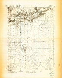
1979 Map of Maroa
USGS Topo · Published 1980About this map
Maroa serves as the central hub of this Central Illinois landscape, situated at the junction of significant transport corridors during the late 1970s. The town is flanked by the Illinois Central Gulf and the Illinois Terminal railroads, reflecting a period when rail infrastructure remained vital to the agricultural economy of the De Witt and Macon County border. To the north, the terrain becomes more varied as it approaches the winding course of Salt Creek and the recreational grounds of Weldon Springs State Park. Smaller community landmarks, such as the Texas Ch and the settlement of Ospur, provide important points of reference for local family history. The map also documents the industrial and leisure aspects of the era, from a Gravel Pit near the creek to the Clinton Country Club and the prominent Radio Tower (WMBD) north of town.
Find a feature on this map
18 named features on this map. Tap any name to fly to it.
Don’t see what you’re looking for? This feature index may not catch every label — zoom into the map to look around manually.
Map Details
Editions of this 1979 Maroa Map
2 editions found
Other maps of this area

1929 · Decatur
USGS Topo · 1:62,500

1933 · Decatur
USGS Topo · 1:62,500

1954 · Niantic
USGS Topo · 1:62,500

1957 · Kenney
USGS Topo · 1:62,500

1957 · Maroa
USGS Topo · 1:62,500

1958 · Peoria
USGS Topo · 1:250,000

1958 · Decatur
USGS Topo · 1:250,000

1961 · Peoria
USGS Topo · 1:250,000

1961 · Decatur
USGS Topo · 1:250,000

1963 · Peoria
USGS Topo · 1:250,000