
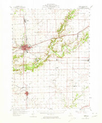
1957 Map of Maroa
USGS Topo · Published 1958About this map
Clinton serves as a major rail hub in this mid-century survey, where the Illinois Central lines intersect at the heart of the county. The landscape is defined by the winding course of Salt Creek, which feeds into the recreational grounds of Weldon Springs Park southeast of the city. Further south, Maroa anchors the agricultural plains where the Pennsylvania railroad cuts across the prairie.
Find a feature on this map
57 named features on this map. Tap any name to fly to it.
Don’t see what you’re looking for? This feature index may not catch every label — zoom into the map to look around manually.
Map Details
Editions of this 1957 Maroa Map
2 editions found
Other maps of this area

1929 · Decatur
USGS Topo · 1:62,500

1933 · Decatur
USGS Topo · 1:62,500

1937 · Monticello
USGS Topo · 1:48,000

1943 · Monticello
USGS Topo · 1:62,500

1949 · Mc Lean
USGS Topo · 1:62,500

1951 · McLean
USGS Topo · 1:62,500

1951 · Le Roy
USGS Topo · 1:62,500

1952 · Arrowsmith
USGS Topo · 1:62,500

1954 · Niantic
USGS Topo · 1:62,500

1955 · Bement
USGS Topo · 1:62,500