1990s Maps of Glen Carbon, Illinois
Explore 4 historic maps of Glen Carbon from the 1990s. These maps offer a rare glimpse into what life looked like during the 1990s — showing old roads, neighborhoods, homes, and landmarks that have changed or disappeared over time.
Whether you're researching your family's past, planning a metal detecting trip, or studying how Glen Carbon's landscape evolved across the 1990s, these high-resolution maps are a powerful tool for exploring the history of this region.
- Focus on a specific era: All maps on this page are from the 1990s, giving you a focused view of this time period.
- See what’s changed: Compare century-old streets, trails, and buildings to today's modern landscape using overlays and satellite layers.
- Research with precision: Use these maps for genealogy, historical research, land use analysis, or educational projects.
- View, download, or print: Maps are fully viewable online in high resolution, and can be downloaded or printed for your own records.
Start exploring Glen Carbon's history through authentic maps from the 1990s. This is your window into the past.
Glen Carbon, IL maps
(4)- 1991 Map of Collinsville
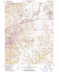 1991 Collinsville1991 Print · USGSThe Collinsville and Troy area comes alive in the early nineties as suburban neighborhoods began to weave through the older rural landscape. Researchers can trace family sites at St Pauls Cem or locate community landmarks like Maryville Sch and Troy Crossing.
 - 1991 Map of Edwardsville
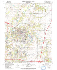 1991 Edwardsville1991 Print · USGSMadison County at the start of the nineties shows the growth of the EDWARDSVILLE and GLEN CARBON communities. Researchers can trace family sites and local landmarks from St Boniface Cem to the early campus layout of SOUTHERN ILLINOIS UNIVERSITY AT EDWARDSVILLE.
 - 1994 Map of Wood River, 1995 Print
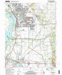 1994 Wood River1995 Print · USGSThe industrial heart of Madison County and the lowlands of the Mississippi floodplain are detailed in this mid-nineties survey. Genealogists and local historians can trace family sites at Springley Cem, the grounds of Southern Illinois University, or the old rail stops at Poag.2 unique versions available
 - 1998 Map of Monks Mound, 1999 Print
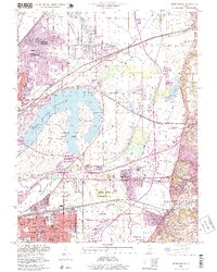 1998 Monks Mound1999 Print · USGSThe American Bottoms region near the Mississippi River was evolving quickly in the late twentieth century as urban industry met ancient landmarks. Genealogists and historians can trace the foundations of Fairmont City and Washington Park while locating Monks Mound and St Johns Cem.
End of results
Showing maps 1-4 of 4
Top cities near Glen Carbon
- St. Louis historical maps
- Belleville historical maps
- O'Fallon historical maps
- Granite City historical maps
- Edwardsville historical maps
- Alton historical maps
See more
Top neighborhoods of Glen Carbon
- Glen Carbon Crossing historical maps
- Heritage Estates historical maps
- Meridian Hills North historical maps
- Oak Ridge Estates historical maps
- Forest Grove historical maps
- Glen Hills historical maps
See more
Frequently asked questions
- What are the different types of historical maps available for Glen Carbon?
- What is the oldest map of Glen Carbon?
- Where can I purchase historical maps of Glen Carbon for my home or office?
- Where can I download high-res historical maps of Glen Carbon?
- Are there historical topographic maps available for Glen Carbon?
- Is there historical aerial imagery available for Glen Carbon?
- Where are historical maps of Glen Carbon sourced from?