1920s Maps of McLean County, Illinois
Explore 4 historic maps of McLean County from the 1920s. These maps offer a rare glimpse into what life looked like during the 1920s — showing old roads, neighborhoods, homes, and landmarks that have changed or disappeared over time.
Whether you're researching your family's past, planning a metal detecting trip, or studying how McLean County's landscape evolved across the 1920s, these high-resolution maps are a powerful tool for exploring the history of this region.
- Focus on a specific era: All maps on this page are from the 1920s, giving you a focused view of this time period.
- See what’s changed: Compare century-old streets, trails, and buildings to today's modern landscape using overlays and satellite layers.
- Research with precision: Use these maps for genealogy, historical research, land use analysis, or educational projects.
- View, download, or print: Maps are fully viewable online in high resolution, and can be downloaded or printed for your own records.
Start exploring McLean County's history through authentic maps from the 1920s. This is your window into the past.
McLean County, IL maps
(4)- 1926 Map of Normal, 1966 Print
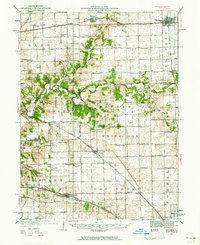
 1926 Normal1966 Print · USGSCentral Illinois rail towns and prairie farmsteads are captured here during the mid-1920s. Genealogists can locate dozens of rural landmarks, including the Union Ch and schoolhouses like Frog Alley Sch and Sixmile Sch.2 unique versions available
 - 1927 Map of Danvers, 1961 Print
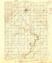
 1927 Danvers1961 Print · USGSCentral Illinois at the end of the roaring twenties was a landscape of dense rail networks and dozens of rural schoolhouses. Genealogists can trace family footprints near Centennial Chapel, the Town Hall, and dozens of district schools like Strubhar Sch or Hopewell Sch.
 - 1928 Map of Gibson City
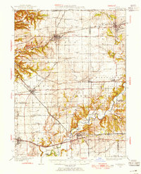
 1928 Gibson City1928 Print · USGSCentral Illinois farming life is captured here in the late 1920s, dominated by the major rail junction at Gibson City. Genealogists can locate dozens of country schools like Scotland School and Caledonia School along the Sangamon River.2 unique versions available
 - 1928 Map of Mackinaw, 1954 Print
 1928 Mackinaw1954 Print · USGSTazewell and Woodford Counties thrived as a major rail hub in the late twenties, balancing rich farmland with bustling rail towns. Genealogists can trace family roots through dozens of district schools like Science Hill Sch and settlements including Morton, Deer Creek, and Allentown.
End of results
Showing maps 1-4 of 4
Top cities of McLean County
- Bloomington historical maps
- Normal historical maps
- Empire historical maps
- Randolph historical maps
- Le Roy historical maps
- Heyworth historical maps
See more
Frequently asked questions
- What are the different types of historical maps available for McLean County?
- What is the oldest map of McLean County?
- Where can I purchase historical maps of McLean County for my home or office?
- Where can I download high-res historical maps of McLean County?
- Are there historical topographic maps available for McLean County?
- Is there historical aerial imagery available for McLean County?
- Where are historical maps of McLean County sourced from?