1970s Maps of McLean County, Illinois
Explore 4 historic maps of McLean County from the 1970s. These maps offer a rare glimpse into what life looked like during the 1970s — showing old roads, neighborhoods, homes, and landmarks that have changed or disappeared over time.
Whether you're researching your family's past, planning a metal detecting trip, or studying how McLean County's landscape evolved across the 1970s, these high-resolution maps are a powerful tool for exploring the history of this region.
- Focus on a specific era: All maps on this page are from the 1970s, giving you a focused view of this time period.
- See what’s changed: Compare century-old streets, trails, and buildings to today's modern landscape using overlays and satellite layers.
- Research with precision: Use these maps for genealogy, historical research, land use analysis, or educational projects.
- View, download, or print: Maps are fully viewable online in high resolution, and can be downloaded or printed for your own records.
Start exploring McLean County's history through authentic maps from the 1970s. This is your window into the past.
McLean County, IL maps
(4)- 1970 Map of El Paso, 1972 Print
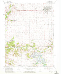 1970 El Paso1972 Print · USGSCentral Illinois during the early seventies shows the city of El Paso at a crossroads of rail and river commerce. Researchers can locate family sites at Centennial Chapel Cem and trace the early development of Evergreen Lake.2 unique versions available
 - 1970 Map of Danvers, 1972 Print
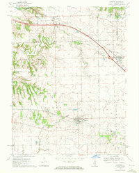 1970 Danvers1972 Print · USGSCentral Illinois prairie life and transit are captured here in the early seventies as new interstates began to parallel historic rail lines. Researchers can trace family sites at Stouts Grove Cem, locate the North Danvers Ch, and follow the Penn Central tracks.
 - 1970 Map of Mackinaw, 1972 Print
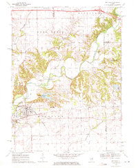 1970 Mackinaw1972 Print · USGSTazewell County's rural heartland is documented here in the early seventies, centered on the Penn Central rail corridor and the winding Mackinaw River. Genealogists and historians can locate the Oak Knoll Sanatorium, old family burials like Stumbaugh Cem, and the small settlement of Lilly.2 unique versions available
 - 1970 Map of Danvers SE, 1972 Print
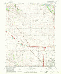 1970 Danvers SE1972 Print · USGSThe rural-urban fringe of McLean County is seen here just as the highway network was reshaping the land. Genealogists can locate numerous small family burial sites like Denman Cem or trace the early footprint of the State University Farm near Normal.2 unique versions available
End of results
Showing maps 1-4 of 4
Top cities of McLean County
- Bloomington historical maps
- Normal historical maps
- Empire historical maps
- Randolph historical maps
- Le Roy historical maps
- Heyworth historical maps
See more
Frequently asked questions
- What are the different types of historical maps available for McLean County?
- What is the oldest map of McLean County?
- Where can I purchase historical maps of McLean County for my home or office?
- Where can I download high-res historical maps of McLean County?
- Are there historical topographic maps available for McLean County?
- Is there historical aerial imagery available for McLean County?
- Where are historical maps of McLean County sourced from?