1960s Maps of Menard County, Illinois
Explore 5 historic maps of Menard County from the 1960s. These maps offer a rare glimpse into what life looked like during the 1960s — showing old roads, neighborhoods, homes, and landmarks that have changed or disappeared over time.
Whether you're researching your family's past, planning a metal detecting trip, or studying how Menard County's landscape evolved across the 1960s, these high-resolution maps are a powerful tool for exploring the history of this region.
- Focus on a specific era: All maps on this page are from the 1960s, giving you a focused view of this time period.
- See what’s changed: Compare century-old streets, trails, and buildings to today's modern landscape using overlays and satellite layers.
- Research with precision: Use these maps for genealogy, historical research, land use analysis, or educational projects.
- View, download, or print: Maps are fully viewable online in high resolution, and can be downloaded or printed for your own records.
Start exploring Menard County's history through authentic maps from the 1960s. This is your window into the past.
Menard County, IL maps
(5)- 1961 Map of Peoria
 1961 Peoria1961 Print · USGSCentral Illinois thrived at the intersection of river trade and rail power during the late fifties. Genealogists and local historians can trace the rail networks of the Illinois Central and Wabash, alongside landmarks like Chanute AFB and Weldon Springs State Park.
 - 1961 Map of Decatur
 1961 Decatur1961 Print · USGSCentral Illinois in the late fifties was a bustling corridor of rail lines and prairie commerce centered on the state capital. Genealogists and historians can trace the intricate connections between Springfield, Decatur, and dozens of smaller settlements like Nokomis and Arcola.2 unique versions available
 - 1963 Map of Peoria
 1963 Peoria1963 Print · USGSCentral Illinois thrived as a rail and highway crossroads during the early sixties, centered on the bustling Illinois River valley. Genealogists and historians can trace the mid-century layout of Peoria, locate the grounds of Chanute Air Force Base, and follow historic lines like the Toledo Peoria and Western Railway.
 - 1966 Map of Athens, 1967 Print
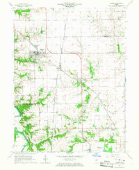 1966 Athens1967 Print · USGSNorth of Springfield in the mid-1960s, this area shows the rail junctions of Athens and Cantrall during a period of steady rural growth. Researchers can trace family history at Brittin Cem or locate the former Barr Station and the Sangamon River oxbows.3 unique versions available
 - 1966 Map of Williamsville, 1967 Print
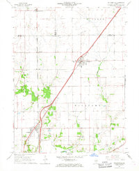 1966 Williamsville1967 Print · USGSCentral Illinois farmland in the mid-sixties shows a landscape defined by rail corridors and creek bottoms. Trace family sites near Williamsville and Sherman, including several old burial grounds like Wolf Creek Cem and Stewart Cem.3 unique versions available
End of results
Showing maps 1-5 of 5
Top cities of Menard County
- Petersburg historical maps
- Athens historical maps
- Greenview historical maps
- Tallula historical maps
- Oakford historical maps
Frequently asked questions
- What are the different types of historical maps available for Menard County?
- What is the oldest map of Menard County?
- Where can I purchase historical maps of Menard County for my home or office?
- Where can I download high-res historical maps of Menard County?
- Are there historical topographic maps available for Menard County?
- Is there historical aerial imagery available for Menard County?
- Where are historical maps of Menard County sourced from?