1950s Maps of Mercer County, Illinois
Explore 15 historic maps of Mercer County from the 1950s. These maps offer a rare glimpse into what life looked like during the 1950s — showing old roads, neighborhoods, homes, and landmarks that have changed or disappeared over time.
Whether you're researching your family's past, planning a metal detecting trip, or studying how Mercer County's landscape evolved across the 1950s, these high-resolution maps are a powerful tool for exploring the history of this region.
- Focus on a specific era: All maps on this page are from the 1950s, giving you a focused view of this time period.
- See what’s changed: Compare century-old streets, trails, and buildings to today's modern landscape using overlays and satellite layers.
- Research with precision: Use these maps for genealogy, historical research, land use analysis, or educational projects.
- View, download, or print: Maps are fully viewable online in high resolution, and can be downloaded or printed for your own records.
Start exploring Mercer County's history through authentic maps from the 1950s. This is your window into the past.
Mercer County, IL maps
(15)- 1953 Map of Viola, 1957 Print
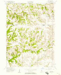
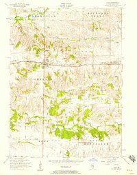 1953 Viola1957 Print · USGSMercer County farmland and rail-side villages appear in the early fifties during the height of the rural school era. Trace local family history through Viola Cemetery, Green Summit School, and the defunct rail stops at Gilchrist or Wanlock.2 unique versions available
 - 1953 Map of Matherville, 1957 Print
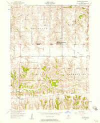
 1953 Matherville1957 Print · USGSThe border of Rock Island and Mercer Counties is shown in the early 1950s as the local coal mining era was fading. Researchers can trace historic industrial sites like the Gilhrist Mine and several rural burial grounds including Farlows Grove Cemetery and Soderberg Cemetery.2 unique versions available
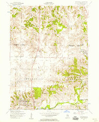
 - 1953 Map of New Windsor, 1957 Print
 1953 New Windsor1957 Print · USGSNorthwestern Illinois farm country in the early fifties shows a transition from local rail reliance to industrial coal extraction. Genealogists can locate family burial plots at Oxford Cemetery or trace the rural school system through sites like Oakridge School and Hopewell School.2 unique versions available
 - 1953 Map of Orion, 1957 Print
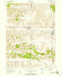
 1953 Orion1957 Print · USGSThe tri-county border of Henry, Rock Island, and Mercer counties appears in the early fifties as a landscape of rural schools and coal works. Researchers can trace family sites at Beulah Church, the Long View Mine, and the Rural Town Hall School.3 unique versions available
 - 1953 Map of Toolesboro, 1958 Print
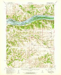
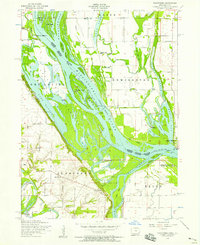 1953 Toolesboro1958 Print · USGSThe Mississippi River valley along the Iowa-Illinois border comes alive in the 1950s, showcasing a landscape of shifting sloughs and river commerce. Genealogists and historians can trace family roots through Mallory Cemetery or locate the site of the New Boston Ferry and local landmarks like Pin Oak School.2 unique versions available
 - 1953 Map of Blanchard Island, 1958 Print
 1953 Blanchard Island1958 Print · USGSThe Mississippi River bottomlands between Illinois and Iowa are captured here in the early fifties, showing a landscape of complex chutes and islands. Genealogists can locate rural landmarks like Island Church, Reynolds Cemetery, and several local schools such as Excelsior School.2 unique versions available
 - 1953 Map of Buffalo Prairie, 1958 Print
 1953 Buffalo Prairie1958 Print · USGSIllinois prairie life in the early fifties comes into focus along the Rock Island and Mercer County line. Researchers can trace the heritage of rural communities through several country schoolhouses and church sites like Buffalo Prairie Church and the Duncan Town Hall.2 unique versions available
 - 1953 Map of Aledo East, 1958 Print
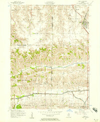
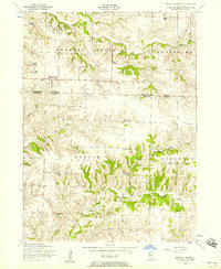
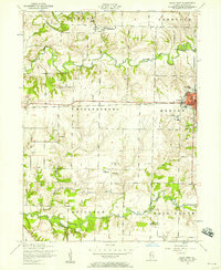
 1953 Aledo East1958 Print · USGSMercer County's rural townships are captured here in the early 1950s, showing a landscape defined by small rail towns and country crossroads. Genealogists can trace family names through sites like Motherred Cemetery, Shale City, and the Mercer County Nursing Home.2 unique versions available
 - 1953 Map of Eliza, 1958 Print
 1953 Eliza1958 Print · USGSWestern Illinois farm country in the early fifties is mapped here in detail, spanning the boundary of Rock Island and Mercer Counties. Researchers can locate local landmarks like the White Eagle School, Miller Cemetery, and the rural community center of Eliza.2 unique versions available
 - 1953 Map of Reynolds, 1958 Print
 1953 Reynolds1958 Print · USGSThe borderlands of Rock Island and Mercer counties are captured here in the early 1950s, showing a landscape shaped by small farmsteads and rural schools. Researchers can trace family sites at Hamlet Cemetery, locate vanished schoolhouses like McAfee School, and follow the path of a dismantled railroad.2 unique versions available
 - 1953 Map of Joy, 1958 Print
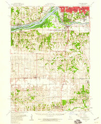
 1953 Joy1958 Print · USGSMercer County, Illinois, is captured in the early 1950s as the rail and river landscape of New Boston and Joy continued to evolve. Researchers can locate rural landmarks like Lone Star School, Shields Cemetery, and the path of the dismantled railroad.2 unique versions available
 - 1953 Map of Aledo West, 1958 Print
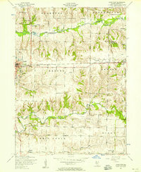
 1953 Aledo West1958 Print · USGSMercer County farmland in the early fifties shows a landscape of busy rural townships and established schools. Researchers can locate the Roosevelt Military Academy in Aledo or trace family sites like Griffith Cemetery and Peniel Church.2 unique versions available
 - 1953 Map of Milan, 1959 Print
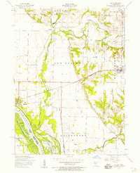
 1953 Milan1959 Print · USGSRock Island County and the Mississippi riverfront are captured here in the mid-fifties, showing the region's transition from river-town industry to suburban growth. Genealogists and historians can locate numerous rural landmarks like St Josephs Ch, Colony Cem, and the old Edgington Sch.
 - 1953 Map of Edgington, 1960 Print
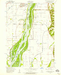
 1953 Edgington1960 Print · USGSThe Mississippi River valley comes alive in the early fifties, showing a landscape of sloughs and islands between Iowa and Illinois. Researchers can trace rural lineages through the Buffalo Prairie Cem, Sweetland Center, and dozens of named schoolhouses.
 - 1958 Map of Davenport, 1968 Print
 1958 Davenport1968 Print · USGSEastern Iowa and western Illinois thrive along the river during the late fifties, defined by the industrial Quad Cities and a robust rail network. Genealogists can trace family roots through settlements like Oasis and Stanwood or along the Cedar River.2 unique versions available
End of results
Showing maps 1-15 of 15
Top cities of Mercer County
- Aledo historical maps
- Preemption historical maps
- Viola historical maps
- Matherville historical maps
- Millersburg historical maps
- Keithsburg historical maps
See more
Frequently asked questions
- What are the different types of historical maps available for Mercer County?
- What is the oldest map of Mercer County?
- Where can I purchase historical maps of Mercer County for my home or office?
- Where can I download high-res historical maps of Mercer County?
- Are there historical topographic maps available for Mercer County?
- Is there historical aerial imagery available for Mercer County?
- Where are historical maps of Mercer County sourced from?