1990s Maps of Taylor Springs, Illinois
Explore 3 historic maps of Taylor Springs from the 1990s. These maps offer a rare glimpse into what life looked like during the 1990s — showing old roads, neighborhoods, homes, and landmarks that have changed or disappeared over time.
Whether you're researching your family's past, planning a metal detecting trip, or studying how Taylor Springs's landscape evolved across the 1990s, these high-resolution maps are a powerful tool for exploring the history of this region.
- Focus on a specific era: All maps on this page are from the 1990s, giving you a focused view of this time period.
- See what’s changed: Compare century-old streets, trails, and buildings to today's modern landscape using overlays and satellite layers.
- Research with precision: Use these maps for genealogy, historical research, land use analysis, or educational projects.
- View, download, or print: Maps are fully viewable online in high resolution, and can be downloaded or printed for your own records.
Start exploring Taylor Springs's history through authentic maps from the 1990s. This is your window into the past.
Taylor Springs, IL maps
(3)- 1998 Map of Sorento North, 2002 Print
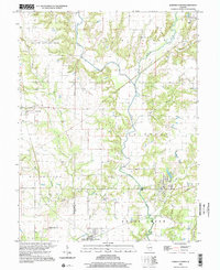 1998 Sorento North2002 Print · USGSThe rural landscapes of Montgomery County are captured here in the late twentieth century as agriculture and small-town life persisted. Researchers can locate family burial sites at Hart Cem and Union Cem, or trace the path of the Old RR Gr near Sorento.
 - 1998 Map of Butler, 2002 Print
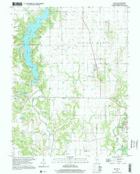 1998 Butler2002 Print · USGSThe village of Butler and the expansive waters of Lake Lou Yaeger define this Montgomery County landscape in the late nineties. Researchers can trace family history at Butler Cem or follow the path of an Old RR Grade and the Middle Fork Shoal Creek.
 - 1998 Map of Coffeenn, 2002 Print
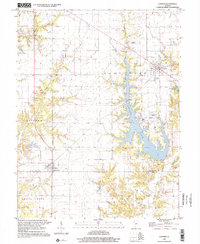 1998 Coffeenn2002 Print · USGSThe Montgomery and Bond County line comes alive in the late 1990s as industrial utility meets rural heritage near the shores of Coffeen Lake. Researchers can trace genealogical roots at Edward Chapel and McDavid Point Cem or explore the power-generation landscape surrounding Coffeen.
End of results
Showing maps 1-3 of 3
Top cities near Taylor Springs
- Greenville historical maps
- Litchfield historical maps
- Hillsboro historical maps
- Nokomis historical maps
- Mount Olive historical maps
- Witt historical maps
See more
Frequently asked questions
- What are the different types of historical maps available for Taylor Springs?
- What is the oldest map of Taylor Springs?
- Where can I purchase historical maps of Taylor Springs for my home or office?
- Where can I download high-res historical maps of Taylor Springs?
- Are there historical topographic maps available for Taylor Springs?
- Is there historical aerial imagery available for Taylor Springs?
- Where are historical maps of Taylor Springs sourced from?