1970s Maps of Taylor Springs, Illinois
Explore 4 historic maps of Taylor Springs from the 1970s. These maps offer a rare glimpse into what life looked like during the 1970s — showing old roads, neighborhoods, homes, and landmarks that have changed or disappeared over time.
Whether you're researching your family's past, planning a metal detecting trip, or studying how Taylor Springs's landscape evolved across the 1970s, these high-resolution maps are a powerful tool for exploring the history of this region.
- Focus on a specific era: All maps on this page are from the 1970s, giving you a focused view of this time period.
- See what’s changed: Compare century-old streets, trails, and buildings to today's modern landscape using overlays and satellite layers.
- Research with precision: Use these maps for genealogy, historical research, land use analysis, or educational projects.
- View, download, or print: Maps are fully viewable online in high resolution, and can be downloaded or printed for your own records.
Start exploring Taylor Springs's history through authentic maps from the 1970s. This is your window into the past.
Taylor Springs, IL maps
(4)- 1974 Map of Butler, 1977 Print
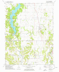 1974 Butler1977 Print · USGSThe northern edge of Hillsboro and the rural township of Butler Grove are documented in the mid-seventies. Researchers can locate local landmarks like Wares Grove Ch and Cress Hill Cem, or trace the ABANDONED rail line near Butler.
 - 1974 Map of Hillsboro, 1977 Print
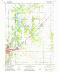 1974 Hillsboro1977 Print · USGSMid-century Montgomery County is centered here around Hillsboro and its neighboring lakefronts during a period of established local industry. Researchers can trace family roots at McCord Cem or locate the old Burbank Sch and Sehram City rail corridor.
 - 1974 Map of Coffeen, 1977 Print
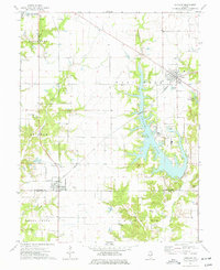 1974 Coffeen1977 Print · USGSCoffeen and Donnellson are captured in the mid-1970s as industrial development reshaped the Montgomery County countryside. Researchers can trace family history at the County Farm Cem or locate industrial landmarks like the Powerplant Stack and the Norfolk and Western rail line.
 - 1974 Map of Sorento North, 1977 Print
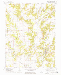 1974 Sorento North1977 Print · USGSMid-century Montgomery County, Illinois, reveals a landscape defined by coal mining and a dense network of competing railroads. Genealogists and historians can trace family roots at Clear Springs Cem or locate industrial sites like the Mine near Panama.
End of results
Showing maps 1-4 of 4
Top cities near Taylor Springs
- Greenville historical maps
- Litchfield historical maps
- Hillsboro historical maps
- Nokomis historical maps
- Mount Olive historical maps
- Witt historical maps
See more
Frequently asked questions
- What are the different types of historical maps available for Taylor Springs?
- What is the oldest map of Taylor Springs?
- Where can I purchase historical maps of Taylor Springs for my home or office?
- Where can I download high-res historical maps of Taylor Springs?
- Are there historical topographic maps available for Taylor Springs?
- Is there historical aerial imagery available for Taylor Springs?
- Where are historical maps of Taylor Springs sourced from?