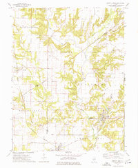
1974 Map of Sorento North
USGS Topo · Published 1977About this map
Industrial and rural landscapes converge across this Montgomery County territory, where coal mining and agriculture once drove the local economy. The town of Panama serves as a focal point near the Mine and Panama Lake, highlighting the area's extraction history. Nearby, the village of Walshville sits along the Burlington Northern railroad, illustrating the critical role of rail transport in moving goods and people between the region's scattered settlements.
Find a feature on this map
42 named features on this map. Tap any name to fly to it.
Don’t see what you’re looking for? This feature index may not catch every label — zoom into the map to look around manually.
Map Details
Editions of this 1974 Sorento North Map
This is the sole edition of this map. No revisions or reprints were ever made.
Other maps of this area

1915 · Mount Olive
USGS Topo · 1:62,500

1932 · Greenville
USGS Topo · 1:62,500

1937 · New Douglas
USGS Topo · 1:48,000

1939 · Greenville
USGS Topo · 1:62,500

1943 · Greenville
USGS Topo · 1:62,500

1944 · New Douglas
USGS Topo · 1:62,500

1944 · Mount Olive
USGS Topo · 1:62,500

1947 · Hillsboro
USGS Topo · 1:62,500

1949 · Hillsboro
USGS Topo · 1:62,500

1958 · Decatur
USGS Topo · 1:250,000