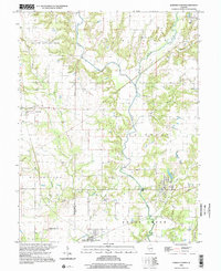
1998 Map of Sorento North
USGS Topo · Published 2002About this map
Shoal Creek dominates the drainage of this central Illinois landscape, where the West Fork Shoal Creek and Middle Fork Shoal Creek converge. The terrain is defined by the rural townships of Hillsboro, Grisham, and Walshville, exhibiting a pattern of small agricultural centers and scattered family cemeteries. The map provides significant detail for genealogists, documenting numerous burial grounds such as Hart Cem, Baptist Cem, and Clear Springs Cem. Transportation history is visible through the Old RR Gr corridor near Sorento and industrial traces like the Quarry and Gas Well south of Panama. A distinctive landmark, Robbs Mound, rises near the Montgomery and Bond County line, while small water bodies like Panama Lake and Waveland Creek thread through the wooded breaks along the creek forks.
Find a feature on this map
35 named features on this map. Tap any name to fly to it.
Don’t see what you’re looking for? This feature index may not catch every label — zoom into the map to look around manually.
Map Details
Editions of this 1998 Sorento North Map
This is the sole edition of this map. No revisions or reprints were ever made.
Other maps of this area

1915 · Mount Olive
USGS Topo · 1:62,500

1932 · Greenville
USGS Topo · 1:62,500

1937 · New Douglas
USGS Topo · 1:48,000

1939 · Greenville
USGS Topo · 1:62,500

1943 · Greenville
USGS Topo · 1:62,500

1944 · New Douglas
USGS Topo · 1:62,500

1944 · Mount Olive
USGS Topo · 1:62,500

1947 · Hillsboro
USGS Topo · 1:62,500

1949 · Hillsboro
USGS Topo · 1:62,500

1958 · Decatur
USGS Topo · 1:250,000