1930s Maps of Jacksonville, Illinois
Explore 5 historic maps of Jacksonville from the 1930s. These maps offer a rare glimpse into what life looked like during the 1930s — showing old roads, neighborhoods, homes, and landmarks that have changed or disappeared over time.
Whether you're researching your family's past, planning a metal detecting trip, or studying how Jacksonville's landscape evolved across the 1930s, these high-resolution maps are a powerful tool for exploring the history of this region.
- Focus on a specific era: All maps on this page are from the 1930s, giving you a focused view of this time period.
- See what’s changed: Compare century-old streets, trails, and buildings to today's modern landscape using overlays and satellite layers.
- Research with precision: Use these maps for genealogy, historical research, land use analysis, or educational projects.
- View, download, or print: Maps are fully viewable online in high resolution, and can be downloaded or printed for your own records.
Start exploring Jacksonville's history through authentic maps from the 1930s. This is your window into the past.
Jacksonville, IL maps
(5)- 1932 Map of Arenzville
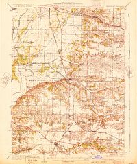 1932 Arenzville1932 Print · USGSThe bluffs and bottomlands of Cass and Morgan Counties are meticulously documented here in the early thirties. Local historians can trace family roots through dozens of rural landmarks, including Jersey College Sch, Bethel Chapel, and the settlement of Joy Prairie.
 - 1932 Map of Jacksonville, 1965 Print
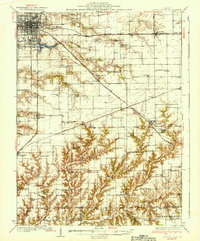
 1932 Jacksonville1965 Print · USGSCentral Illinois farm country and the growing hub of Jacksonville are captured in the early 1930s before modern highway expansion. Researchers can trace dozens of country schools and churches, including Douglas Institute, Whitlock Cem, and the rural post at Pisgah.2 unique versions available
 - 1932 Map of Virginia, 1965 Print
 1932 Virginia1965 Print · USGSCentral Illinois farm country and the Sangamon river breaks are captured here in the early 1930s as the rail and road network matured. Researchers can locate dozens of country schools and churches, from Brush College Sch and Zion Ch to the old settlement of Old Princeton.2 unique versions available
 - 1936 Map of Virginia
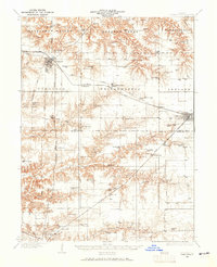
 1936 Virginia1936 Print · USGSCentral Illinois during the mid-thirties shows a landscape of busy rail towns and rural school districts centered on Virginia and Ashland. Researchers can trace old family schoolhouses like Science Hill Sch and country churches such as Eckman Chapel.2 unique versions available
 - 1937 Map of Jacksonville
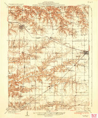
 1937 Jacksonville1937 Print · USGSMid-century Morgan County thrives as a rail and education hub just before the pre-war era. Researchers can trace ancestral roots at Whitlock Cem or locate defunct schools like Sulphur Springs Sch and Prairie College Sch.2 unique versions available
End of results
Showing maps 1-5 of 5
Top cities near Jacksonville
- South Jacksonville historical maps
- Virginia historical maps
- Winchester historical maps
- Ashland historical maps
- Murrayville historical maps
- Chapin historical maps
See more
Frequently asked questions
- What are the different types of historical maps available for Jacksonville?
- What is the oldest map of Jacksonville?
- Where can I purchase historical maps of Jacksonville for my home or office?
- Where can I download high-res historical maps of Jacksonville?
- Are there historical topographic maps available for Jacksonville?
- Is there historical aerial imagery available for Jacksonville?
- Where are historical maps of Jacksonville sourced from?