1980s Maps of Jacksonville, Illinois
Explore 5 historic maps of Jacksonville from the 1980s. These maps offer a rare glimpse into what life looked like during the 1980s — showing old roads, neighborhoods, homes, and landmarks that have changed or disappeared over time.
Whether you're researching your family's past, planning a metal detecting trip, or studying how Jacksonville's landscape evolved across the 1980s, these high-resolution maps are a powerful tool for exploring the history of this region.
- Focus on a specific era: All maps on this page are from the 1980s, giving you a focused view of this time period.
- See what’s changed: Compare century-old streets, trails, and buildings to today's modern landscape using overlays and satellite layers.
- Research with precision: Use these maps for genealogy, historical research, land use analysis, or educational projects.
- View, download, or print: Maps are fully viewable online in high resolution, and can be downloaded or printed for your own records.
Start exploring Jacksonville's history through authentic maps from the 1980s. This is your window into the past.
Jacksonville, IL maps
(5)- 1983 Map of Jacksonville
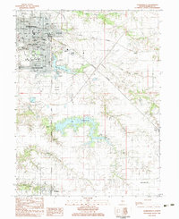 1983 Jacksonville1983 Print · USGSJacksonville and Morgan County are captured here in the early eighties, showcasing a dense network of colleges, specialized schools, and medical institutions. Researchers can trace historic family burial sites at East Cem and Diamond Grove Cem or locate the sprawling grounds of Illinois College.
 - 1983 Map of Lynnville
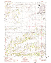 1983 Lynnville1983 Print · USGSJacksonville and its rural outskirts come into focus in the early 1980s, showing the city's western expansion toward the Morgan County line. Researchers can locate several burial sites including Lynnville Cem and Lewis Cem, or trace the Norfolk and Western rail line.
 - 1983 Map of Concord
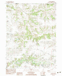 1983 Concord1983 Print · USGSMorgan County in the early eighties shows a landscape defined by traditional agriculture and essential rail links. Genealogists can trace family names through numerous rural burial sites like Caldwell Cem and find landmarks such as Ebenezer Ch.
 - 1983 Map of Literberry
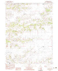 1983 Literberry1983 Print · USGSMorgan County in the early 1980s maintains its deep agricultural roots between the crossroads of Literberry and Arcadia. Genealogists can trace family lineages through numerous local burial sites like Oak Ridge Cem and Phillips Cem or locate old landmarks like North Sch.
 - 1985 Map of Meredosia, 1988 Print
 1985 Meredosia1988 Print · USGSWest Central Illinois in the mid-eighties was a landscape of deep-rooted river towns and historic educational institutions. Genealogists and historians can trace family ties through Diamond Grove Cem, locate MacMurray College in Jacksonville, or study the river engineering at La Grange Lock and Dam.
End of results
Showing maps 1-5 of 5
Top cities near Jacksonville
- South Jacksonville historical maps
- Virginia historical maps
- Winchester historical maps
- Ashland historical maps
- Murrayville historical maps
- Chapin historical maps
See more
Frequently asked questions
- What are the different types of historical maps available for Jacksonville?
- What is the oldest map of Jacksonville?
- Where can I purchase historical maps of Jacksonville for my home or office?
- Where can I download high-res historical maps of Jacksonville?
- Are there historical topographic maps available for Jacksonville?
- Is there historical aerial imagery available for Jacksonville?
- Where are historical maps of Jacksonville sourced from?