1900s (20th Century) Maps of Pana, Illinois
Explore 9 historic maps of Pana from the 1900s (20th Century). These maps offer a rare glimpse into what life looked like during the 1900s — showing old roads, neighborhoods, homes, and landmarks that have changed or disappeared over time.
Whether you're researching your family's past, planning a metal detecting trip, or studying how Pana's landscape evolved across the 1900s, these high-resolution maps are a powerful tool for exploring the history of this region.
- Focus on a specific era: All maps on this page are from the 1900s, giving you a focused view of this time period.
- See what’s changed: Compare century-old streets, trails, and buildings to today's modern landscape using overlays and satellite layers.
- Research with precision: Use these maps for genealogy, historical research, land use analysis, or educational projects.
- View, download, or print: Maps are fully viewable online in high resolution, and can be downloaded or printed for your own records.
Start exploring Pana's history through authentic maps from the 1900s. This is your window into the past.
Pana, IL maps
(9)- 1947 Map of Pana
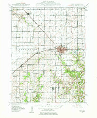 1947 Pana1947 Print · USGSRailroad lines from three major carriers converge at Pana in the mid-1940s, serving a productive agricultural landscape across three counties. Researchers can locate dozens of country schools and churches, including Swamp Angel School, Sacred Heart Cem, and Owaneco.
 - 1949 Map of Pana
 1949 Pana1949 Print · USGSCentral Illinois rail traffic peaked in the late 1940s as five major lines converged at the hub of Pana. Researchers can trace the rural school system and family burial grounds such as Durbin College Sch and Mound Cem.2 unique versions available
 - 1958 Map of Decatur, 1971 Print
 1958 Decatur1971 Print · USGSCentral Illinois in the mid-twentieth century shows a landscape defined by industrial rail hubs and the creation of large reservoirs. Researchers can trace historic corridors like the Penn Central or locate landmarks such as Lincoln Log Cabin State Park and Lake Springfield.3 unique versions available
 - 1961 Map of Decatur
 1961 Decatur1961 Print · USGSCentral Illinois in the late fifties was a bustling corridor of rail lines and prairie commerce centered on the state capital. Genealogists and historians can trace the intricate connections between Springfield, Decatur, and dozens of smaller settlements like Nokomis and Arcola.2 unique versions available
 - 1982 Map of Litchfield
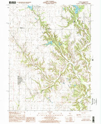
 1982 Litchfield1982 Print · USGSThe coal and rail corridors of Central Illinois are captured here in the early eighties as the region balanced industrial mining with its agricultural roots. Researchers can trace family history through sites like Zelmer Memorial Cemetery or the grounds of Blackburn College and the Crown Mine No 1.
 - 1982 Map of Pana
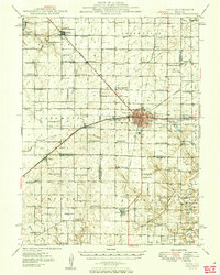
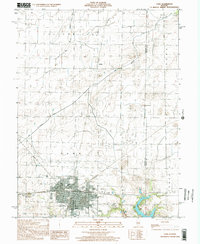
 1982 Pana1982 Print · USGSThe rail-driven hub of Pana is captured here in the early eighties, showcasing its crossroads as a center for transport and local industry. Genealogists and historians can trace family plots at Linwood Cem or explore the layout of the Tri County Fairground and Kehias Park.
 - 1982 Map of Oconee
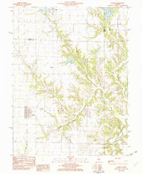 1982 Oconee1982 Print · USGSShelby and Christian counties in the early eighties were still defined by traditional rail corridors and rural parishes. Genealogists can trace family landmarks like Oconee Mound Cem, Hopewell Ch, and the Illinois Central Gulf line.
 - 1998 Map of Pana, 2002 Print
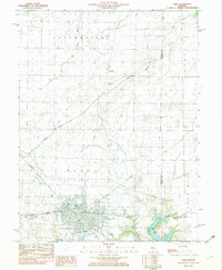
 1998 Pana2002 Print · USGSChristian and Shelby Counties come together at the turn of the millennium in this detailed study of the area. Researchers can trace family sites at Mound Cem, locate the Tri County Fairground, or follow the Main Drainage Ditch through the prairie.
 - 1998 Map of Oconee, 2002 Print
 1998 Oconee2002 Print · USGSThe rural border of Christian and Shelby counties comes into focus in the late nineties, showing a landscape shaped by prairie farming and deep creek valleys. Researchers can trace the village of Oconee, locate the Sacred Heart Cem, or find the Oconee Mound Cem.
End of results
Showing maps 1-9 of 9
Top cities near Pana
- Taylorville historical maps
- Shelbyville historical maps
- Nokomis historical maps
- Assumption historical maps
- Tower Hill historical maps
- Cowden historical maps
See more
Frequently asked questions
- What are the different types of historical maps available for Pana?
- What is the oldest map of Pana?
- Where can I purchase historical maps of Pana for my home or office?
- Where can I download high-res historical maps of Pana?
- Are there historical topographic maps available for Pana?
- Is there historical aerial imagery available for Pana?
- Where are historical maps of Pana sourced from?