1990s Maps of Pana, Illinois
Explore 2 historic maps of Pana from the 1990s. These maps offer a rare glimpse into what life looked like during the 1990s — showing old roads, neighborhoods, homes, and landmarks that have changed or disappeared over time.
Whether you're researching your family's past, planning a metal detecting trip, or studying how Pana's landscape evolved across the 1990s, these high-resolution maps are a powerful tool for exploring the history of this region.
- Focus on a specific era: All maps on this page are from the 1990s, giving you a focused view of this time period.
- See what’s changed: Compare century-old streets, trails, and buildings to today's modern landscape using overlays and satellite layers.
- Research with precision: Use these maps for genealogy, historical research, land use analysis, or educational projects.
- View, download, or print: Maps are fully viewable online in high resolution, and can be downloaded or printed for your own records.
Start exploring Pana's history through authentic maps from the 1990s. This is your window into the past.
Pana, IL maps
(2)- 1998 Map of Pana, 2002 Print
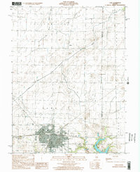 1998 Pana2002 Print · USGSChristian and Shelby Counties come together at the turn of the millennium in this detailed study of the area. Researchers can trace family sites at Mound Cem, locate the Tri County Fairground, or follow the Main Drainage Ditch through the prairie.
 - 1998 Map of Oconee, 2002 Print
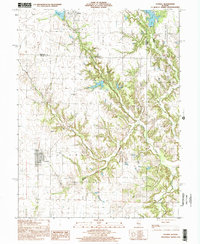 1998 Oconee2002 Print · USGSThe rural border of Christian and Shelby counties comes into focus in the late nineties, showing a landscape shaped by prairie farming and deep creek valleys. Researchers can trace the village of Oconee, locate the Sacred Heart Cem, or find the Oconee Mound Cem.
End of results
Showing maps 1-2 of 2
Top cities near Pana
- Taylorville historical maps
- Shelbyville historical maps
- Nokomis historical maps
- Assumption historical maps
- Tower Hill historical maps
- Cowden historical maps
See more
Frequently asked questions
- What are the different types of historical maps available for Pana?
- What is the oldest map of Pana?
- Where can I purchase historical maps of Pana for my home or office?
- Where can I download high-res historical maps of Pana?
- Are there historical topographic maps available for Pana?
- Is there historical aerial imagery available for Pana?
- Where are historical maps of Pana sourced from?