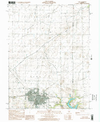
1998 Map of Pana
USGS Topo · Published 2002About this map
Pana serves as the focal point of this late 20th-century survey, situated at the boundary of Christian and Shelby Counties. The grid of the town is well-defined, showing the distribution of civic life through the High Sch, Hospital, and several historical burial grounds including Calvary Cem, Mound Cem, and Linwood Cem. The surrounding township lands of Assumption, Rural, and Tower Hill are marked by a complex system of water management, featuring the Main Drainage Ditch and Big Ditch which navigate the low-lying prairie terrain.
Find a feature on this map
22 named features on this map. Tap any name to fly to it.
Don’t see what you’re looking for? This feature index may not catch every label — zoom into the map to look around manually.
Map Details
Editions of this 1998 Pana Map
This is the sole edition of this map. No revisions or reprints were ever made.
Other maps of this area

1942 · Shelbyville
USGS Topo · 1:62,500

1946 · Shelbyville
USGS Topo · 1:62,500

1947 · Pana
USGS Topo · 1:62,500

1949 · Dalton City
USGS Topo · 1:62,500

1949 · Pana
USGS Topo · 1:62,500

1952 · Assumption
USGS Topo · 1:62,500

1958 · Decatur
USGS Topo · 1:250,000

1961 · Decatur
USGS Topo · 1:250,000

1974 · Willeys
USGS Topo · 1:24,000
1981 · Lakewood
USGS Topo · 1:24,000