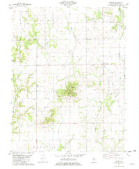
1981 Map of Lakewood
USGS Topo · Published 1982About this map
Williamsburg Hill rises above the rural landscape of Shelby County, anchoring a terrain defined by the winding paths of Becks Creek and Mitchell Creek. This early 1980s record captures the region’s agricultural and industrial character, where extractive sites like Gravel Pits and numerous Sandpits dot the countryside. The Baltimore and Ohio railroad corridor serves as a primary transit artery, passing through the village of Lakewood and an adjacent Oil Field. For genealogists and local historians, the sheet is exceptionally dense with family-named landmarks and burial sites, including McCoy Cem, Corley Cem, and Horsman Cem. The distribution of these cemeteries, alongside structures like the Townhall and West New Hope Ch, reflects the enduring settlement patterns of townships such as Cold Spring and Tower Hill.
Find a feature on this map
34 named features on this map. Tap any name to fly to it.
Don’t see what you’re looking for? This feature index may not catch every label — zoom into the map to look around manually.
Map Details
Editions of this 1981 Lakewood Map
This is the sole edition of this map. No revisions or reprints were ever made.
Other maps of this area

1941 · St. Elmo
USGS Topo · 1:62,500

1942 · Shelbyville
USGS Topo · 1:62,500

1944 · Ramsey
USGS Topo · 1:62,500

1945 · St. Elmo
USGS Topo · 1:62,500

1946 · Shelbyville
USGS Topo · 1:62,500

1946 · Ramsey
USGS Topo · 1:62,500

1947 · Pana
USGS Topo · 1:62,500

1949 · Pana
USGS Topo · 1:62,500

1958 · Decatur
USGS Topo · 1:250,000

1961 · Decatur
USGS Topo · 1:250,000