1800s (19th Century) Maps of Peoria County, Illinois
Explore 3 historic maps of Peoria County from the 1800s (19th Century). These maps offer a rare glimpse into what life looked like during the 1800s — showing old roads, neighborhoods, homes, and landmarks that have changed or disappeared over time.
Whether you're researching your family's past, planning a metal detecting trip, or studying how Peoria County's landscape evolved across the 1800s, these high-resolution maps are a powerful tool for exploring the history of this region.
- Focus on a specific era: All maps on this page are from the 1800s, giving you a focused view of this time period.
- See what’s changed: Compare century-old streets, trails, and buildings to today's modern landscape using overlays and satellite layers.
- Research with precision: Use these maps for genealogy, historical research, land use analysis, or educational projects.
- View, download, or print: Maps are fully viewable online in high resolution, and can be downloaded or printed for your own records.
Start exploring Peoria County's history through authentic maps from the 1800s. This is your window into the past.
Peoria County, IL maps
(3)- 1893 Map of Metamora
 1893 Metamora1893 Print · USGSWoodford and Marshall counties are shown in the 1890s as the rail networks and river towns of the Illinois valley reached maturity. Researchers can trace the early footprints of Metamora, Washburn, and Rome alongside the path of the Chicago and Alton Railroad.4 unique versions available
 - 1893 Map of Dunlap
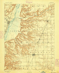
 1893 Dunlap1893 Print · USGSPeoria County and the Illinois River valley are seen here in the 1890s, when the region was a bustling network of rail towns and river bluffs. Genealogists can trace family roots in early settlements like Dunlap, Princeville, and the river community of Mossville.
 - 1898 Map of Dunlap
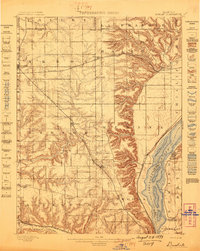 1898 Dunlap1898 Print · USGSPeoria County and its neighboring townships thrive along the river bluffs and rail lines during the late 1890s. Researchers can trace the path of the Atchison Topeka and Santa Fe Railroad and locate vanished rural centers like Wady Petra and Orange Prairie.4 unique versions available
End of results
Showing maps 1-3 of 3
Top cities of Peoria County
- Peoria historical maps
- Bartonville historical maps
- Chillicothe historical maps
- West Peoria historical maps
- Kickapoo historical maps
- Elmwood historical maps
See more
Frequently asked questions
- What are the different types of historical maps available for Peoria County?
- What is the oldest map of Peoria County?
- Where can I purchase historical maps of Peoria County for my home or office?
- Where can I download high-res historical maps of Peoria County?
- Are there historical topographic maps available for Peoria County?
- Is there historical aerial imagery available for Peoria County?
- Where are historical maps of Peoria County sourced from?