1970s Maps of Peoria County, Illinois
Explore 11 historic maps of Peoria County from the 1970s. These maps offer a rare glimpse into what life looked like during the 1970s — showing old roads, neighborhoods, homes, and landmarks that have changed or disappeared over time.
Whether you're researching your family's past, planning a metal detecting trip, or studying how Peoria County's landscape evolved across the 1970s, these high-resolution maps are a powerful tool for exploring the history of this region.
- Focus on a specific era: All maps on this page are from the 1970s, giving you a focused view of this time period.
- See what’s changed: Compare century-old streets, trails, and buildings to today's modern landscape using overlays and satellite layers.
- Research with precision: Use these maps for genealogy, historical research, land use analysis, or educational projects.
- View, download, or print: Maps are fully viewable online in high resolution, and can be downloaded or printed for your own records.
Start exploring Peoria County's history through authentic maps from the 1970s. This is your window into the past.
Peoria County, IL maps
- 1971 Map of Hanna City, 1973 Print
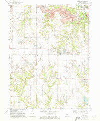 1971 Hanna City1973 Print · USGSHanna City and Logan Township are captured here in the early 1970s as industrial mining and new residential lake developments began to reshape the Peoria County prairie. Researchers can trace the Chicago and North Western tracks and locate local landmarks like the Hanna City Boys Sch and Smithville Cem.2 unique versions available
 - 1971 Map of Germantown Hills, 1973 Print
 1971 Germantown Hills1973 Print · USGSWoodford County's rolling upland ridges and deep creek valleys are captured in the early 1970s as Germantown Hills began to expand. Genealogists can locate Black Partridge Cem, St Marys Cem, and the Mount Alverno Novitiate among the timbered bluffs.2 unique versions available
 - 1971 Map of Oak Hill, 1973 Print
 1971 Oak Hill1973 Print · USGSPeoria County rural life and industry are captured here in the early seventies, centered on the villages of Brimfield and Oak Hill. Genealogists and historians can trace the Burlington Northern line and find remote burial sites like Lutheran Cem and Combs Cem.2 unique versions available
 - 1971 Map of Dunlap, 1973 Print
 1971 Dunlap1973 Print · USGSPeoria's northern rural fringe in the early 1970s shows the transition from quiet township life to suburban growth. Genealogists and historians can locate family plots at St Clements Cem, trace the old rail lines, and find vanished landmarks like the Drive-in Theater and Grange Hall.2 unique versions available
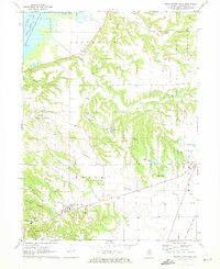
 - 1971 Map of Glasford, 1974 Print
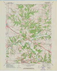
 1971 Glasford1974 Print · USGSThe Illinois River valley in the early 1970s reveals a landscape defined by heavy industry and small-town roots. Researchers can trace local genealogy through Lancaster Cem and Union Cem, or explore the industrial riverfront near Kingston Mines.
 - 1972 Map of Chillicothe, 1974 Print
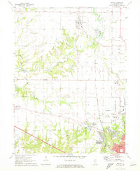
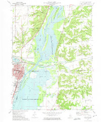 1972 Chillicothe1974 Print · USGSChillicothe and the Illinois River valley are captured in the early seventies as a major rail-and-river hub surrounded by expansive conservation wetlands. Genealogists can locate family landmarks such as Hammett Cem, New Salem Cem, and Lincoln Valley Central High Sch.2 unique versions available
End of results
Showing maps 1-6
Top cities of Peoria County
- Peoria historical maps
- Bartonville historical maps
- Chillicothe historical maps
- West Peoria historical maps
- Kickapoo historical maps
- Elmwood historical maps
See more
Frequently asked questions
- What are the different types of historical maps available for Peoria County?
- What is the oldest map of Peoria County?
- Where can I purchase historical maps of Peoria County for my home or office?
- Where can I download high-res historical maps of Peoria County?
- Are there historical topographic maps available for Peoria County?
- Is there historical aerial imagery available for Peoria County?
- Where are historical maps of Peoria County sourced from?