1950s Maps of Pope County, Illinois
Explore 11 historic maps of Pope County from the 1950s. These maps offer a rare glimpse into what life looked like during the 1950s — showing old roads, neighborhoods, homes, and landmarks that have changed or disappeared over time.
Whether you're researching your family's past, planning a metal detecting trip, or studying how Pope County's landscape evolved across the 1950s, these high-resolution maps are a powerful tool for exploring the history of this region.
- Focus on a specific era: All maps on this page are from the 1950s, giving you a focused view of this time period.
- See what’s changed: Compare century-old streets, trails, and buildings to today's modern landscape using overlays and satellite layers.
- Research with precision: Use these maps for genealogy, historical research, land use analysis, or educational projects.
- View, download, or print: Maps are fully viewable online in high resolution, and can be downloaded or printed for your own records.
Start exploring Pope County's history through authentic maps from the 1950s. This is your window into the past.
Pope County, IL maps
(11)- 1950 Map of Paducah
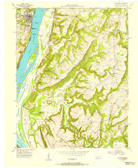
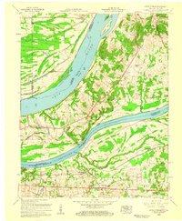
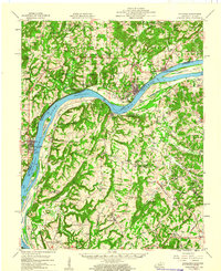
 1950 Paducah1950 Print · USGSThe confluence of the great midwestern rivers defines this mid-century landscape at the intersection of Illinois, Kentucky, and Missouri. Genealogists and historians can trace the rail-and-river economy through the hubs of Paducah, Cairo, and Metropolis or locate family roots near the Wildcat Hills.
 - 1954 Map of Paducah
 1954 Paducah1954 Print · USGSSouthern Illinois and Western Kentucky intersect at the great river confluences during this mid-century era of rail and river industry. Genealogists and historians can trace family roots and commerce through river towns like Cairo, Metropolis, and Golconda, or along the tracks of the Illinois Central Railroad.2 unique versions available
 - 1954 Map of Golconda, 1955 Print
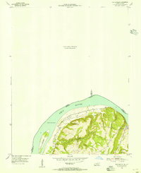
 1954 Golconda1955 Print · USGSThe riverfront of the early fifties is preserved here, showing the navigational hub at Golconda and the massive Pryor Island. Genealogists can trace rural life through landmarks like Wagman Chapel, Joy Sch, and the isolated Duley Bluff Cem.3 unique versions available
 - 1954 Map of Shetlerville, 1955 Print
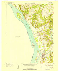
 1954 Shetlerville1955 Print · USGSLivingston County, Kentucky, and Pope County, Illinois, meet at a sweeping bend in the river during the mid-fifties. Genealogists and local historians can trace the paths around Carrsville or locate Loves Cem and the winding Givens Foot Trail.
 - 1954 Map of Smithland, 1955 Print
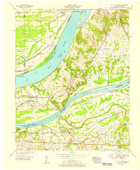
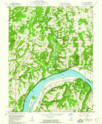
 1954 Smithland1955 Print · USGSThe river confluence at Smithland in the mid-1950s remains a landscape rich in Civil War history and family heritage. Researchers can trace the Historical Hospital (Civil War), find the Silver Mine, and locate ancestral burials at Cowper Cem.
 - 1954 Map of Little Cypress, 1956 Print
 1954 Little Cypress1956 Print · USGSThe confluence of the great rivers in Western Kentucky and Southern Illinois is captured here in the mid-1950s. Trace family roots and local industry at Kincaid Mounds, the community of Possum Trot, and along the tracks of the ILLINOIS CENTRAL.
 - 1958 Map of Little Cypress, 1959 Print
 1958 Little Cypress1959 Print · USGSLivingston and Marshall Counties meet at the river forks in the late fifties, showing a landscape shaped by the Ohio River and Tennessee River. You can trace family roots at Vaughn Chapel or Oak Grove Cem and locate the rail lines through Little Cypress.2 unique versions available
 - 1959 Map of Herod, 1960 Print
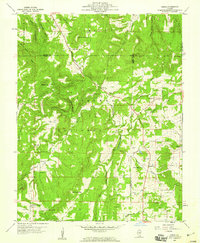 1959 Herod1960 Print · USGSSouthern Illinois in the late fifties is captured here at the intersection of industry and the Shawnee National Forest. Researchers can trace old family names at Wallace Cem, locate forgotten sites like Empire Mine, or find rural landmarks such as One Horse Gap.3 unique versions available
 - 1959 Map of Equality, 1960 Print
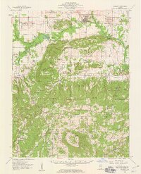 1959 Equality1960 Print · USGSSouthern Illinois during the late fifties reveals a landscape of transition between the industrial river valleys and the wooded heights of the Shawnee National Forest. Researchers can locate deep-rooted community sites like Equality, the Salt Wells, and remote locations such as One Horse Gap.2 unique versions available
 - 1959 Map of Shetlerville, 1960 Print
 1959 Shetlerville1960 Print · USGSThe riverfront and timberlands of the Ohio Valley are captured here in the late fifties, showing the interplay of the Ohio River and the Shawnee National Forest. Researchers can locate old family burial sites like Twitchell Cem and trace the legacy of mining at the Baker Mine and Parkinson Mine.3 unique versions available
 - 1959 Map of Golconda, 1960 Print
 1959 Golconda1960 Print · USGSThe Ohio River valley at the edge of the Shawnee National Forest comes alive in the late fifties, showing a landscape defined by river traffic and upland mining. Trace local history through family-named landmarks like McMurray Chapel, Mantle Rock, and the Empire Gem Mine.2 unique versions available
End of results
Showing maps 1-11 of 11
Top cities of Pope County
Frequently asked questions
- What are the different types of historical maps available for Pope County?
- What is the oldest map of Pope County?
- Where can I purchase historical maps of Pope County for my home or office?
- Where can I download high-res historical maps of Pope County?
- Are there historical topographic maps available for Pope County?
- Is there historical aerial imagery available for Pope County?
- Where are historical maps of Pope County sourced from?