1990s Maps of Pope County, Illinois
Explore 11 historic maps of Pope County from the 1990s. These maps offer a rare glimpse into what life looked like during the 1990s — showing old roads, neighborhoods, homes, and landmarks that have changed or disappeared over time.
Whether you're researching your family's past, planning a metal detecting trip, or studying how Pope County's landscape evolved across the 1990s, these high-resolution maps are a powerful tool for exploring the history of this region.
- Focus on a specific era: All maps on this page are from the 1990s, giving you a focused view of this time period.
- See what’s changed: Compare century-old streets, trails, and buildings to today's modern landscape using overlays and satellite layers.
- Research with precision: Use these maps for genealogy, historical research, land use analysis, or educational projects.
- View, download, or print: Maps are fully viewable online in high resolution, and can be downloaded or printed for your own records.
Start exploring Pope County's history through authentic maps from the 1990s. This is your window into the past.
Pope County, IL maps
(11)- 1996 Map of Stonefort, 1998 Print
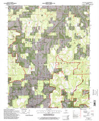
 1996 Stonefort1998 Print · USGSIn the mid-1990s, the border between Saline and Pope Counties preserved a dense collection of rural heritage sites within the Shawnee National Forest. Genealogists and local historians can locate long-standing landmarks like Bolton Cem, Reagan Sch, and Little Flock Ch.
 - 1996 Map of Waltersburg, 1998 Print
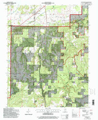
 1996 Waltersburg1998 Print · USGSPope County, Illinois, was a landscape of remote farmsteads and timbered tracts during the mid-nineties. Genealogists can trace family names and community roots through landmarks like Whiteside Cem, Palestine Ch, and the settlement of Raum.2 unique versions available
 - 1996 Map of Paducah NE, 1998 Print
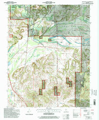
 1996 Paducah NE1998 Print · USGSMassac County and the Shawnee National Forest appear here in the mid-1990s, just as modern imagery updated the record of this rural landscape. Genealogists and local historians can locate dozens of small landmarks, from Unity Sch and Mt Sterling Ch to family burial sites like Golightly Cem and Pell Cem.2 unique versions available
 - 1996 Map of Herod, 1998 Print
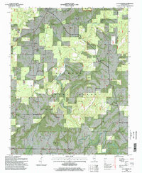
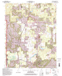
 1996 Herod1998 Print · USGSThe Illinois Ozarks come alive in this mid-nineties survey of the Shawnee National Forest. Researchers can trace rural lineages through numerous remote burial sites like Old Grand Pierre Cem and explore the geography of the Empire Mine or One Horse Gap.
 - 1996 Map of Eddyville, 1998 Print
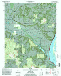
 1996 Eddyville1998 Print · USGSPope and Saline counties in the mid-1990s reveal a landscape of deep creek valleys and protected timberlands within the Shawnee National Forest. Genealogists can trace family names at the Morse Cem, McNally Cem, and Palestine Ch.
 - 1996 Map of Brownfield, 1998 Print
 1996 Brownfield1998 Print · USGSThe Ohio River shoreline and Shawnee National Forest define this landscape in the mid-1990s. Researchers can trace family history through dozens of rural sites like Old Brownfield, Bradford Cem, and Community High Sch.
 - 1996 Map of Golconda, 1998 Print
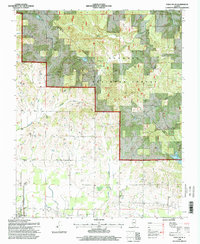
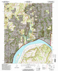
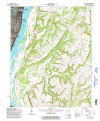 1996 Golconda1998 Print · USGSThe Ohio River bank at Golconda and the interior uplands of the Shawnee National Forest are shown here in the late twentieth century. Researchers can locate the Golconda Historic District, trace old family plots at Lay Cem, and find rural schoolhouses like Joy Sch.
 - 1996 Map of Reevesville, 1998 Print
 1996 Reevesville1998 Print · USGSIn the mid-1990s, this southern Illinois landscape remained a network of bottomland farms and timbered tracts where three counties meet. Genealogists can trace family roots at Benton Ch Cem and Wilkins Cem, or locate the site of Bay Valley Sch near the Illinois Central RR.
 - 1996 Map of Smithland, 1998 Print
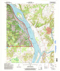 1996 Smithland1998 Print · USGSThe confluence of the Ohio and Cumberland Rivers comes alive in the late 1990s, anchored by the river town of Smithland. Genealogists and historians can trace family burial sites like Kickapoo Cem and Dunlap Cem or find industry at the Dyer Hill Mine.
 - 1996 Map of Shetlerville, 1998 Print
 1996 Shetlerville1998 Print · USGSThe Ohio River corridor at the Illinois-Kentucky border is shown here in the mid-1990s as a landscape of national forest and river engineering. Genealogists can trace family landmarks like Dutton Cem and Vaughn Cem near settlements like Shetlerville and Eichorn.
 - 1996 Map of Glendale, 1998 Print
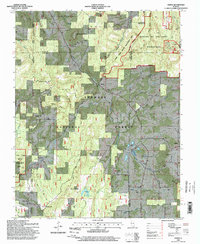
 1996 Glendale1998 Print · USGSSouthern Illinois in the 1990s reveals a landscape of protected forests and deep history. Genealogists and historians can trace family roots at Harper Cem or explore the prehistoric significance of the Millstone Bluff National Register Site.
End of results
Showing maps 1-11 of 11
Top cities of Pope County
Frequently asked questions
- What are the different types of historical maps available for Pope County?
- What is the oldest map of Pope County?
- Where can I purchase historical maps of Pope County for my home or office?
- Where can I download high-res historical maps of Pope County?
- Are there historical topographic maps available for Pope County?
- Is there historical aerial imagery available for Pope County?
- Where are historical maps of Pope County sourced from?