1940s Maps of O'Fallon, Illinois
Explore 1 historic maps of O'Fallon from the 1940s. These maps offer a rare glimpse into what life looked like during the 1940s — showing old roads, neighborhoods, homes, and landmarks that have changed or disappeared over time.
Whether you're researching your family's past, planning a metal detecting trip, or studying how O'Fallon's landscape evolved across the 1940s, these high-resolution maps are a powerful tool for exploring the history of this region.
- Focus on a specific era: All maps on this page are from the 1940s, giving you a focused view of this time period.
- See what’s changed: Compare century-old streets, trails, and buildings to today's modern landscape using overlays and satellite layers.
- Research with precision: Use these maps for genealogy, historical research, land use analysis, or educational projects.
- View, download, or print: Maps are fully viewable online in high resolution, and can be downloaded or printed for your own records.
Start exploring O'Fallon's history through authentic maps from the 1940s. This is your window into the past.
O'Fallon, IL maps
(1)- 1949 Map of Lebanon
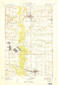 1949 Lebanon1949 Print · USGSSt. Clair County in the late 1940s is captured here at the intersection of rural heritage and military expansion. Genealogists and researchers can trace family-named sites like Espenschied Chapel, Rentchler Sch, and McKendree College.2 unique versions available
End of results
Showing maps 1-1 of 1
Top cities near O'Fallon
- Belleville historical maps
- Granite City historical maps
- Edwardsville historical maps
- Collinsville historical maps
- East St. Louis historical maps
- Fairview Heights historical maps
See more
Top neighborhoods of O'Fallon
- Carbon historical maps
- Glenview historical maps
- Petersburg historical maps
- Gettysburg historical maps
- Estates at Lincoln Farm historical maps
- Forest Hills historical maps
See more
Frequently asked questions
- What are the different types of historical maps available for O'Fallon?
- What is the oldest map of O'Fallon?
- Where can I purchase historical maps of O'Fallon for my home or office?
- Where can I download high-res historical maps of O'Fallon?
- Are there historical topographic maps available for O'Fallon?
- Is there historical aerial imagery available for O'Fallon?
- Where are historical maps of O'Fallon sourced from?