1900s (20th Century) Maps of Saline County, Illinois
Explore 43 historic maps of Saline County from the 1900s (20th Century). These maps offer a rare glimpse into what life looked like during the 1900s — showing old roads, neighborhoods, homes, and landmarks that have changed or disappeared over time.
Whether you're researching your family's past, planning a metal detecting trip, or studying how Saline County's landscape evolved across the 1900s, these high-resolution maps are a powerful tool for exploring the history of this region.
- Focus on a specific era: All maps on this page are from the 1900s, giving you a focused view of this time period.
- See what’s changed: Compare century-old streets, trails, and buildings to today's modern landscape using overlays and satellite layers.
- Research with precision: Use these maps for genealogy, historical research, land use analysis, or educational projects.
- View, download, or print: Maps are fully viewable online in high resolution, and can be downloaded or printed for your own records.
Start exploring Saline County's history through authentic maps from the 1900s. This is your window into the past.
Saline County, IL maps
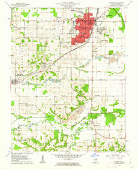
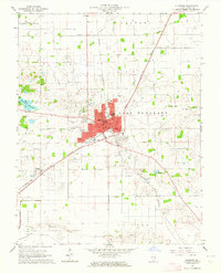
(43)- 1905 Map of Eldorado, 1954 Print
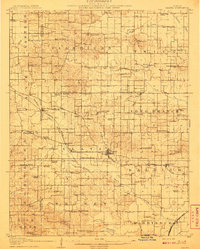
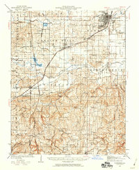
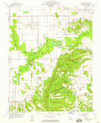
 1905 Eldorado1954 Print · USGSSouthern Illinois rail hubs and prairie settlements thrive at the turn of the century. Genealogists can trace family roots through old stops like Texas City, Gossett, and Francis Mills, or locate early industrial sites like the Dering Mine.
 - 1906 Map of Eldorado
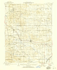
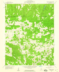
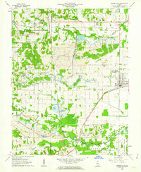
 1906 Eldorado1906 Print · USGSSouthern Illinois at the turn of the century is a bustling web of competing rail lines and river-bottom settlements. Genealogists and rail historians can trace the early footprints of Eldorado, Ridgway, and the milling history at Francis Mills.2 unique versions available
 - 1908 Map of Galatia
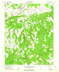
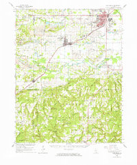
 1908 Galatia1908 Print · USGSSouthern Illinois at the dawn of the twentieth century was a landscape of thriving rural communities and rail-side towns. Genealogists can trace family roots through numerous local landmarks like Possum Flat School, Tate Township Hall, and Mount Pleasant Church.2 unique versions available
 - 1916 Map of Equality
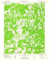
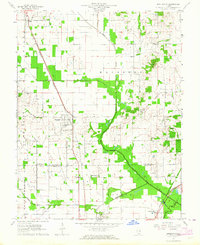
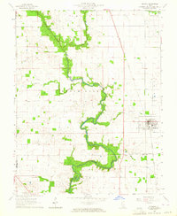
 1916 Equality1916 Print · USGSSouthern Illinois before the First World War shows a landscape defined by the Saline River and industrial outposts. Genealogists and historians can trace family locations near Loves Store, explore the site of the Illinois Furnace, or locate vanished schoolhouses like Pisgah School.4 unique versions available
 - 1925 Map of Harrisburg
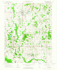
 1925 Harrisburg1925 Print · USGSSouthern Illinois coal country is in its prime during the 1920s, showing a landscape of rail-connected mining towns and remote hill settlements. Genealogists can locate dozens of country schools and churches like Mayhew School and Salem Church, alongside industrial landmarks like Wasson Mine No 2.3 unique versions available
 - 1938 Map of Galatia, 1959 Print
 1938 Galatia1959 Print · USGSThe Southern Illinois interior near the Saline River comes to life in this survey from the late thirties. Genealogists and historians can trace family roots through numerous local landmarks like Thistle Ridge School, Tate Chapel, and Akin.
 - 1939 Map of Harrisburg, 1959 Print
 1939 Harrisburg1959 Print · USGSSouthern Illinois at the end of the Depression era reveals a landscape of growing coal towns and dozens of rural school districts. Genealogists can trace family connections at Ward Cem, Stonefort, and rural outposts like McCormick and Allenby.
 - 1949 Map of Paducah
 1949 Paducah1949 Print · USGSThe confluence of the Ohio, Mississippi, Tennessee, and Cumberland rivers at the close of the 1940s reveals a region bound by water and rail. Researchers can trace historic river landings, timberlands in the Shawnee National Forest, and the coal-mining infrastructure around West Frankfort and Herrin.2 unique versions available
 - 1950 Map of Paducah
 1950 Paducah1950 Print · USGSThe confluence of the great midwestern rivers defines this mid-century landscape at the intersection of Illinois, Kentucky, and Missouri. Genealogists and historians can trace the rail-and-river economy through the hubs of Paducah, Cairo, and Metropolis or locate family roots near the Wildcat Hills.
 - 1954 Map of Paducah
 1954 Paducah1954 Print · USGSSouthern Illinois and Western Kentucky intersect at the great river confluences during this mid-century era of rail and river industry. Genealogists and historians can trace family roots and commerce through river towns like Cairo, Metropolis, and Golconda, or along the tracks of the Illinois Central Railroad.2 unique versions available
 - 1959 Map of Herod, 1960 Print
 1959 Herod1960 Print · USGSSouthern Illinois in the late fifties is captured here at the intersection of industry and the Shawnee National Forest. Researchers can trace old family names at Wallace Cem, locate forgotten sites like Empire Mine, or find rural landmarks such as One Horse Gap.3 unique versions available
 - 1959 Map of Equality, 1960 Print
 1959 Equality1960 Print · USGSSouthern Illinois during the late fifties reveals a landscape of transition between the industrial river valleys and the wooded heights of the Shawnee National Forest. Researchers can locate deep-rooted community sites like Equality, the Salt Wells, and remote locations such as One Horse Gap.2 unique versions available
 - 1959 Map of Equality, 1960 Print
 1959 Equality1960 Print · USGSSouthern Illinois at the end of the fifties reveals a landscape shaped by river transport and the early salt trade. Local historians can trace rail lines and mineral sites like the Negro Spring Salt Well, Berkel Mine, and the village of Equality.3 unique versions available
 - 1959 Map of Rudement, 1960 Print
 1959 Rudement1960 Print · USGSSaline County’s coal-mining and agricultural landscape is captured here in the late fifties as the Shawnee National Forest meets the industrial Strip Mines. Researchers can locate family landmarks including Big Saline Ch, Rocky Branch Sch, and the Coffee Cem near Rudement.3 unique versions available
 - 1959 Map of Karbers Ridge, 1960 Print
 1959 Karbers Ridge1960 Print · USGSSouthern Illinois at the end of the fifties reveals a landscape of high timber and scattered upland farms within the Shawnee National Forest. Genealogists and hikers can trace the paths to Hicks Dome, the Lookout Tower at High Knob, and more than a dozen family cemeteries like Sneed Cem.3 unique versions available
 - 1961 Map of Paducah
 1961 Paducah1961 Print · USGSThe Lower Ohio Valley at mid-century is a landscape defined by its great rivers and newly formed reservoirs. Researchers can trace the riverfronts of Paducah and Metropolis, or locate smaller settlements like Old Shawneetown and Cave in Rock along the banks.2 unique versions available
 - 1961 Map of Stonefort, 1962 Print
 1961 Stonefort1962 Print · USGSSouthern Illinois at the start of the sixties shows a network of family cemeteries and rural parishes tucked between the ridges of the Shawnee National Forest. Genealogists can trace family names at Rushing Cem and Old Zion Cem, or locate the Reagan Sch and McCormick Lookout Tower.2 unique versions available
 - 1961 Map of Eddyville, 1962 Print
 1961 Eddyville1962 Print · USGSSouthern Illinois during the early sixties reveals a landscape of deep forests and scattered rural hollows. Genealogists can trace family roots at Morse Cem, Zimmer Cem, and remote landmarks like Buzzard Roost Hollow.3 unique versions available
 - 1961 Map of Harrisburg, 1962 Print
 1961 Harrisburg1962 Print · USGSSaline County industry and rural life intersect in the early sixties as coal mining shapes the landscape around Harrisburg. Genealogists and historians can locate numerous family burial grounds like Moore-Vinson Cem and rural centers such as Carrier Mills and Ledford.2 unique versions available
 - 1961 Map of Carrier Mills, 1962 Print
 1961 Carrier Mills1962 Print · USGSSouthern Illinois coal country is shown here in the early sixties, centered on the busy rail hub of Carrier Mills. Genealogists and local historians can trace the intersection of industry and community at Dykersburg Sch, Jenny Ridge Cem, and the Sahara Mine No 7.3 unique versions available
 - 1961 Map of Harrisburg, 1965 Print
 1961 Harrisburg1965 Print · USGSSouthern Illinois coal country and forest lands meet in the early sixties as the rail networks of the New York Central serve a landscape of active mines. Researchers can locate family cemeteries and vanished stops like Dykersburg, Newcastle, and the Sahara Mine No 16 Cem.
 - 1963 Map of Broughton, 1964 Print
 1963 Broughton1964 Print · USGSSouthern Illinois during the early sixties is captured here as a landscape of rail-dependent villages and rural parishes. Genealogists can locate family landmarks like Gholson Grove Ch, Broughton Sch, and Latham Cem along the Louisville and Nashville line.
 - 1963 Map of Ridgway, 1964 Print
 1963 Ridgway1964 Print · USGSGallatin County’s river-fed plains are captured here in the early sixties, showing a landscape defined by agriculture and extraction. Genealogists and historians can trace family locations near Ridgway, find rural landmarks like Zion Ch, or study the Omaha Oil and Gas Field.2 unique versions available
 - 1963 Map of Eldorado, 1964 Print
 1963 Eldorado1964 Print · USGSMid-century Saline County is defined here by the intersection of three major railroads and a thriving petroleum industry. Researchers can trace family history through sites like Wolf Creek Cemetery, Wesley Chapel, and the settlement of Wasson.
 - 1963 Map of Norris City, 1964 Print
 1963 Norris City1964 Print · USGSSouthern Illinois during the early sixties is captured here at the rail junction of Norris City and the rural prairies of White County. Researchers can trace ancestral sites like the Odd Fellows Cem and vanished landmarks such as Gossett Station.2 unique versions available
Showing maps 1-25 of 43
Top cities of Saline County
- Harrisburg historical maps
- Eldorado historical maps
- Carrier Mills historical maps
- Galatia historical maps
- Raleigh historical maps
- Long Branch historical maps
See more
Frequently asked questions
- What are the different types of historical maps available for Saline County?
- What is the oldest map of Saline County?
- Where can I purchase historical maps of Saline County for my home or office?
- Where can I download high-res historical maps of Saline County?
- Are there historical topographic maps available for Saline County?
- Is there historical aerial imagery available for Saline County?
- Where are historical maps of Saline County sourced from?