1970s Maps of Schuyler County, Illinois
Explore 10 historic maps of Schuyler County from the 1970s. These maps offer a rare glimpse into what life looked like during the 1970s — showing old roads, neighborhoods, homes, and landmarks that have changed or disappeared over time.
Whether you're researching your family's past, planning a metal detecting trip, or studying how Schuyler County's landscape evolved across the 1970s, these high-resolution maps are a powerful tool for exploring the history of this region.
- Focus on a specific era: All maps on this page are from the 1970s, giving you a focused view of this time period.
- See what’s changed: Compare century-old streets, trails, and buildings to today's modern landscape using overlays and satellite layers.
- Research with precision: Use these maps for genealogy, historical research, land use analysis, or educational projects.
- View, download, or print: Maps are fully viewable online in high resolution, and can be downloaded or printed for your own records.
Start exploring Schuyler County's history through authentic maps from the 1970s. This is your window into the past.
Schuyler County, IL maps
(10)- 1974 Map of Doddsville, 1977 Print
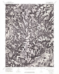
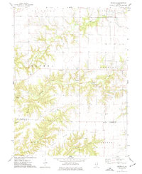 1974 Doddsville1977 Print · USGSThe McDonough and Schuyler County line in the mid-1970s is a landscape of winding creek valleys and high ridges. Researchers can trace local history through numerous burial sites like Stoneking Cem and Pennington Cem or locate the Strip Mine near Grindstone Creek.
 - 1974 Map of Industry, 1977 Print
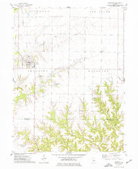 1974 Industry1977 Print · USGSMcDonough and Schuyler Counties in the mid-seventies show a landscape of traditional township farming and rural church life. Genealogists can trace family names through sites like Peck Cem, Standard Cem, and the West Prairie Ch.
 - 1974 Map of Fandon, 1978 Print
 1974 Fandon1978 Print · USGSThe western Illinois borderlands of McDonough and Schuyler counties appear here in the mid-1970s, defined by the winding La Moine River. Genealogists and historians can locate rural landmarks like the White Flock Cem, the Colmar - Plymouth Oil Field, and the settlement of Birmingham.
 - 1974 Map of Plymouth, 1978 Print
 1974 Plymouth1978 Print · USGSHancock and McDonough counties meet here in the mid-1970s, where rural industry and rail lines converge. Genealogists and historians can trace the Colmar - Plymouth Oil Field and family sites like Trimble Cem or Irwin Cem.
 - 1975 Map of Augusta NW, 1976 Print
 1975 Augusta NW1976 Print · USGSIllinois farmland and rural settlements are captured in high-detail aerial photography during the mid-seventies. Researchers can pinpoint specific farmsteads and the historic town layouts of Augusta and La Prairie as they existed fifty years ago.
 - 1975 Map of Beardstown SW, 1976 Print
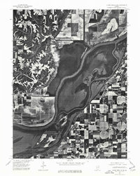
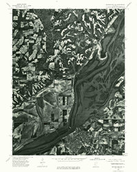 1975 Beardstown SW1976 Print · USGSBeardstown and the surrounding river bottoms are captured in high detail in the mid-1970s, showing the town at a significant confluence. Genealogists and local historians can trace the street layouts of Beardstown and the upland settlement of Pleasant View.
 - 1975 Map of Rushville SE, 1976 Print
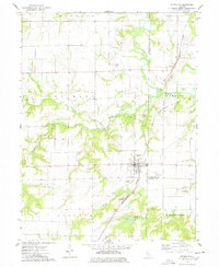
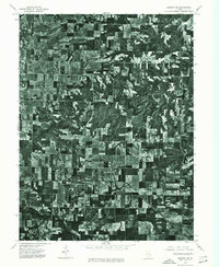
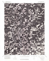
 1975 Rushville SE1976 Print · USGSSchuyler County farmland and the southern outskirts of Rushville are captured in high detail during the mid-seventies. Trace the winding course of the La Moine River and examine the precise layout of local timber and farm fields.
 - 1975 Map of Augusta SW, 1976 Print
 1975 Augusta SW1976 Print · USGSEastern Adams County is captured in mid-1970s aerial detail, revealing the precise layout of agricultural fields and rural roads. Genealogists and researchers can trace the specific footprints of farmsteads and the street grids of Clayton and Timewell.
 - 1975 Map of Chandlerville NW, 1976 Print
 1975 Chandlerville NW1976 Print · USGSThe Illinois riverfront near Mason County comes to life in this mid-seventies aerial survey. Researchers can trace the layout of Bath and study the detailed agricultural patterns and backwaters surrounding the Illinois River.
 - 1975 Map of Rushville NE, 1976 Print
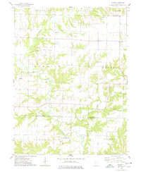
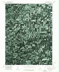
 1975 Rushville NE1976 Print · USGSSchuyler County farmland is captured in sharp aerial detail during the mid-seventies, showing the rural landscape between Littleton and Rushville. Researchers can trace old property lines and the wooded breaks of Sugar Creek.
End of results
Showing maps 1-10 of 10
Top cities of Schuyler County
- Rushville historical maps
- Brooklyn historical maps
- Littleton historical maps
- Frederick historical maps
- Huntsville historical maps
- Birmingham historical maps
See more
Frequently asked questions
- What are the different types of historical maps available for Schuyler County?
- What is the oldest map of Schuyler County?
- Where can I purchase historical maps of Schuyler County for my home or office?
- Where can I download high-res historical maps of Schuyler County?
- Are there historical topographic maps available for Schuyler County?
- Is there historical aerial imagery available for Schuyler County?
- Where are historical maps of Schuyler County sourced from?