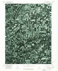
1975 Map of Augusta NW
USGS Topo · Published 1976About this map
Augusta and La Prairie anchor this mid-1970s orthophotograph, providing a detailed photographic record of the agricultural landscape in Schuyler County. The map is built from high-altitude aerial imagery taken on May 1, 1975, revealing the precise layout of farmsteads, woodlots, and drainage patterns across the Illinois prairie. This specialized series, produced by the U.S. Geological Survey and the State Geological Survey, uses photoimagery instead of traditional topographic line work to show the actual footprint of the land as it appeared during the spring planting season. Genealogists and local historians can use this visual data to identify the exact location of historical rural structures and field boundaries that are often simplified on standard contour maps.
Find a feature on this map
2 named features on this map. Tap any name to fly to it.
Don’t see what you’re looking for? This feature index may not catch every label — zoom into the map to look around manually.
Map Details
Editions of this 1975 Augusta NW Map
This is the sole edition of this map. No revisions or reprints were ever made.
Other maps of this area

1913 · Colchester
USGS Topo · 1:62,500

1933 · Carthage
USGS Topo · 1:62,500

1937 · Carthage
USGS Topo · 1:62,500

1946 · Augusta
USGS Topo · 1:62,500

1948 · Camp Point
USGS Topo · 1:62,500

1949 · Augusta
USGS Topo · 1:62,500

1958 · Burlington
USGS Topo · 1:250,000

1961 · Burlington
USGS Topo · 1:250,000

1963 · Burlington
USGS Topo · 1:250,000
1974 · Bentley
USGS Topo · 1:24,000