1980s Maps of Freeport, Illinois
Explore 2 historic maps of Freeport from the 1980s. These maps offer a rare glimpse into what life looked like during the 1980s — showing old roads, neighborhoods, homes, and landmarks that have changed or disappeared over time.
Whether you're researching your family's past, planning a metal detecting trip, or studying how Freeport's landscape evolved across the 1980s, these high-resolution maps are a powerful tool for exploring the history of this region.
- Focus on a specific era: All maps on this page are from the 1980s, giving you a focused view of this time period.
- See what’s changed: Compare century-old streets, trails, and buildings to today's modern landscape using overlays and satellite layers.
- Research with precision: Use these maps for genealogy, historical research, land use analysis, or educational projects.
- View, download, or print: Maps are fully viewable online in high resolution, and can be downloaded or printed for your own records.
Start exploring Freeport's history through authentic maps from the 1980s. This is your window into the past.
Freeport, IL maps
(2)- 1981 Map of Rockford
 1981 Rockford1981 Print · USGSNorthern Illinois during the early eighties shows a landscape shaped by river valleys and a maturing rail network. Genealogists can trace family roots through settlements like Morseville and Buckhorn Corners while exploring the Rock River valley.2 unique versions available
 - 1983 Map of Shannon, 1984 Print
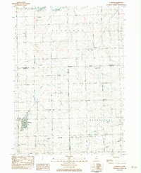 1983 Shannon1984 Print · USGSThe village of Shannon and its neighboring hamlets are captured in the early eighties as the agricultural landscape of Carroll and Stephenson counties continued to evolve. Researchers can locate the Gold Mine on its namesake road, trace the Chicago Milwaukee St Paul and Pacific rail line, or find local family sites at Shell Cem and Prairie Dell Ch.
End of results
Showing maps 1-2 of 2
Top cities near Freeport
- Mount Morris historical maps
- Lena historical maps
- Forreston historical maps
- Lanark historical maps
- Rock Grove historical maps
- Oneco historical maps
See more
Top neighborhoods of Freeport
- Campus Estates historical maps
- Cherokee Hills historical maps
- Cliff Creek Estates historical maps
- Countryside Estates historical maps
- Windwood historical maps
- Winter Heights historical maps
See more
Frequently asked questions
- What are the different types of historical maps available for Freeport?
- What is the oldest map of Freeport?
- Where can I purchase historical maps of Freeport for my home or office?
- Where can I download high-res historical maps of Freeport?
- Are there historical topographic maps available for Freeport?
- Is there historical aerial imagery available for Freeport?
- Where are historical maps of Freeport sourced from?