1960s Maps of Oakwood, Illinois
Explore 2 historic maps of Oakwood from the 1960s. These maps offer a rare glimpse into what life looked like during the 1960s — showing old roads, neighborhoods, homes, and landmarks that have changed or disappeared over time.
Whether you're researching your family's past, planning a metal detecting trip, or studying how Oakwood's landscape evolved across the 1960s, these high-resolution maps are a powerful tool for exploring the history of this region.
- Focus on a specific era: All maps on this page are from the 1960s, giving you a focused view of this time period.
- See what’s changed: Compare century-old streets, trails, and buildings to today's modern landscape using overlays and satellite layers.
- Research with precision: Use these maps for genealogy, historical research, land use analysis, or educational projects.
- View, download, or print: Maps are fully viewable online in high resolution, and can be downloaded or printed for your own records.
Start exploring Oakwood's history through authentic maps from the 1960s. This is your window into the past.
Oakwood, IL maps
(2)- 1968 Map of Oakwood, 1969 Print
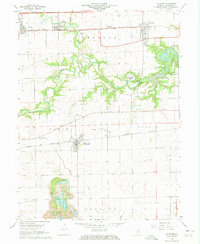 1968 Oakwood1969 Print · USGSVermilion County in the late sixties shows a landscape defined by the winding Salt Fork and active industry. Researchers can trace the Penn Central rail line through Fithian or locate family history at Hickman Cem and Daugherty Cem.3 unique versions available
 - 1968 Map of Collison, 1970 Print
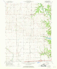 1968 Collison1970 Print · USGSVermilion County's prairie and river breaks are captured here in the late sixties, showing a landscape of established farmsteads and rural rail towns. Trace local lineages through numerous burial sites like Higginsville Cem or the vanished school at Newtown Sch.2 unique versions available
End of results
Showing maps 1-2 of 2
Top cities near Oakwood
- Danville historical maps
- Georgetown historical maps
- Westville historical maps
- Tilton historical maps
- Catlin historical maps
- Homer historical maps
See more
Frequently asked questions
- What are the different types of historical maps available for Oakwood?
- What is the oldest map of Oakwood?
- Where can I purchase historical maps of Oakwood for my home or office?
- Where can I download high-res historical maps of Oakwood?
- Are there historical topographic maps available for Oakwood?
- Is there historical aerial imagery available for Oakwood?
- Where are historical maps of Oakwood sourced from?