1950s Maps of Elwood, Illinois
Explore 4 historic maps of Elwood from the 1950s. These maps offer a rare glimpse into what life looked like during the 1950s — showing old roads, neighborhoods, homes, and landmarks that have changed or disappeared over time.
Whether you're researching your family's past, planning a metal detecting trip, or studying how Elwood's landscape evolved across the 1950s, these high-resolution maps are a powerful tool for exploring the history of this region.
- Focus on a specific era: All maps on this page are from the 1950s, giving you a focused view of this time period.
- See what’s changed: Compare century-old streets, trails, and buildings to today's modern landscape using overlays and satellite layers.
- Research with precision: Use these maps for genealogy, historical research, land use analysis, or educational projects.
- View, download, or print: Maps are fully viewable online in high resolution, and can be downloaded or printed for your own records.
Start exploring Elwood's history through authentic maps from the 1950s. This is your window into the past.
Elwood, IL maps
(4)- 1953 Map of Elwood, 1955 Print
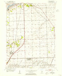 1953 Elwood1955 Print · USGSNear the village of Elwood in the early fifties, the landscape was defined by the massive expansion of the Joliet Arsenal and a heavy rail network. Local historians can trace old schoolhouse sites like Rose Hill Sch and Brown Sch alongside the Old Indian Bdy.3 unique versions available
 - 1954 Map of Channahon, 1955 Print
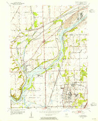 1954 Channahon1955 Print · USGSWill County at mid-century reveals a landscape shaped by major river junctions and the legacy of the canal era. Researchers can trace historical property lines and infrastructure through Channahon, finding detail on landmarks like Willard Grove Cem, Smith Bridge, and the Schweizer Sch.4 unique versions available
 - 1954 Map of Wilmington, 1960 Print
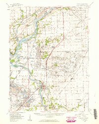 1954 Wilmington1960 Print · USGSWill and Grundy counties in the mid-fifties show a landscape of industrial convergence where major railroads meet the state's storied canal systems. Researchers can trace the Old Indian Boundary or locate family sites like the Soldiers Widows Home and Willard Grove Cem.3 unique versions available
 - 1958 Map of Aurora, 1969 Print
 1958 Aurora1969 Print · USGSNorthern Illinois in the late fifties shows a landscape of powerful river industry and expanding transport corridors. Genealogists and historians can trace the development of Aurora and Joliet or locate sites like the Elwood Ordnance Plant and Starved Rock.3 unique versions available
End of results
Showing maps 1-4 of 4
Top cities near Elwood
- Joliet historical maps
- Bolingbrook historical maps
- Orland Park historical maps
- Plainfield historical maps
- Romeoville historical maps
- New Lenox historical maps
See more
Frequently asked questions
- What are the different types of historical maps available for Elwood?
- What is the oldest map of Elwood?
- Where can I purchase historical maps of Elwood for my home or office?
- Where can I download high-res historical maps of Elwood?
- Are there historical topographic maps available for Elwood?
- Is there historical aerial imagery available for Elwood?
- Where are historical maps of Elwood sourced from?