1950s Maps of Woodford County, Illinois
Explore 5 historic maps of Woodford County from the 1950s. These maps offer a rare glimpse into what life looked like during the 1950s — showing old roads, neighborhoods, homes, and landmarks that have changed or disappeared over time.
Whether you're researching your family's past, planning a metal detecting trip, or studying how Woodford County's landscape evolved across the 1950s, these high-resolution maps are a powerful tool for exploring the history of this region.
- Focus on a specific era: All maps on this page are from the 1950s, giving you a focused view of this time period.
- See what’s changed: Compare century-old streets, trails, and buildings to today's modern landscape using overlays and satellite layers.
- Research with precision: Use these maps for genealogy, historical research, land use analysis, or educational projects.
- View, download, or print: Maps are fully viewable online in high resolution, and can be downloaded or printed for your own records.
Start exploring Woodford County's history through authentic maps from the 1950s. This is your window into the past.
Woodford County, IL maps
(5)- 1950 Map of Spring Bay
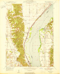 1950 Spring Bay1950 Print · USGSPeoria Lake and the Illinois River valley are seen here just after the war, showing the industrial and recreational growth of the riverfront. Researchers can locate the Mt Hawley Airport, the rail corridor of the Chicago Rock Island and Pacific, and the wooded hollows of Detweiller Park.2 unique versions available
 - 1950 Map of Peoria East
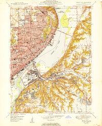 1950 Peoria East1950 Print · USGSPeoria and the Illinois River valley are shown here just after the war, at a peak of industrial and urban density. Genealogists and local historians can trace hundreds of family and community landmarks, from Springdale Cemetery to the neighborhoods of Creve Coeur and Peoria Heights.
 - 1955 Map of Minonk, 1956 Print
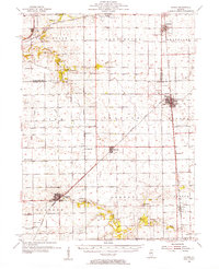 1955 Minonk1956 Print · USGSWoodford and Marshall counties at mid-century reveal a thriving rail-and-coal economy across the Illinois prairie. Family researchers and historians can trace lineage at Mennonite Ch, find old Mine Dumps, or locate vanished landmarks like Spring Hill Sch.
 - 1958 Map of Flanagan, 1959 Print
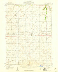 1958 Flanagan1959 Print · USGSNorth-central Illinois townships during the late fifties show a landscape of thriving rail-side hamlets and rural parish life. Genealogists can locate family landmarks like the Salem Childrens Home, Nigh Chapel, and the Morris Cem near the Vermilion River.2 unique versions available
 - 1958 Map of Peoria, 1969 Print
 1958 Peoria1969 Print · USGSCentral Illinois thrived as a hub of education and transport during the late sixties, as the new interstate system began to reshape the prairie. Genealogists and historians can trace local landmarks like Springdale Cem, Bradley University, and the sprawling grounds of Chanute AFB.4 unique versions available
End of results
Showing maps 1-5 of 5
Top cities of Woodford County
- Eureka historical maps
- El Paso historical maps
- Metamora historical maps
- Germantown Hills historical maps
- Minonk historical maps
- Roanoke historical maps
See more
Frequently asked questions
- What are the different types of historical maps available for Woodford County?
- What is the oldest map of Woodford County?
- Where can I purchase historical maps of Woodford County for my home or office?
- Where can I download high-res historical maps of Woodford County?
- Are there historical topographic maps available for Woodford County?
- Is there historical aerial imagery available for Woodford County?
- Where are historical maps of Woodford County sourced from?