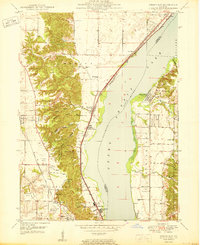
1950 Map of Spring Bay
USGS Topo · Published 1950About this map
Peoria Lake and the Illinois River dominate this mid-century landscape, carving a wide valley between the wooded bluffs of Medina and Partridge. On the western shore, the Chicago Rock Island and Pacific railroad parallels the water, connecting industrial and residential hubs like Sankoty and Peoria Heights with the smaller village of Rome. The uplands are defined by a series of dramatic drainages, including Strawberry Hollow and Poppet Hollow, which feed into the river valley.
Find a feature on this map
49 named features on this map. Tap any name to fly to it.
Don’t see what you’re looking for? This feature index may not catch every label — zoom into the map to look around manually.
Map Details
Editions of this 1950 Spring Bay Map
2 editions found
Other maps of this area

1893 · Metamora
USGS Topo · 1:62,500

1893 · Dunlap
USGS Topo · 1:62,500

1898 · Dunlap
USGS Topo · 1:62,500

1905 · Peoria
USGS Topo · 1:62,500

1927 · Peoria
USGS Topo · 1:62,500

1928 · Mackinaw
USGS Topo · 1:62,500

1932 · Mackinaw
USGS Topo · 1:62,500

1932 · Dunlap
USGS Topo · 1:62,500

1933 · Dunlap
USGS Topo · 1:62,500

1937 · Metamora
USGS Topo · 1:62,500