1940s Maps of Bartholomew County, Indiana
Explore 9 historic maps of Bartholomew County from the 1940s. These maps offer a rare glimpse into what life looked like during the 1940s — showing old roads, neighborhoods, homes, and landmarks that have changed or disappeared over time.
Whether you're researching your family's past, planning a metal detecting trip, or studying how Bartholomew County's landscape evolved across the 1940s, these high-resolution maps are a powerful tool for exploring the history of this region.
- Focus on a specific era: All maps on this page are from the 1940s, giving you a focused view of this time period.
- See what’s changed: Compare century-old streets, trails, and buildings to today's modern landscape using overlays and satellite layers.
- Research with precision: Use these maps for genealogy, historical research, land use analysis, or educational projects.
- View, download, or print: Maps are fully viewable online in high resolution, and can be downloaded or printed for your own records.
Start exploring Bartholomew County's history through authentic maps from the 1940s. This is your window into the past.
Bartholomew County, IN maps
(9)- 1942 Map of Franklin
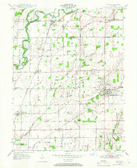
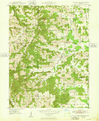
 1942 Franklin1942 Print · USGSCentral Indiana during the early years of the war shows a landscape of established rail towns and growing military installations. Genealogists can trace family names across small settlements like Nineveh, Bean Blossom, and Helmsburg, or locate the Indiana University Observatory.
 - 1942 Map of Columbus
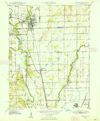
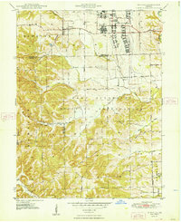
 1942 Columbus1942 Print · USGSBartholomew and Shelby counties are shown during the early years of the war, as military installations and rail lines reshaped the rural Indiana landscape. Genealogists can trace family-named sites and established communities like St Louis Crossing, Hope, and the sprawling Camp Atterbury.
 - 1947 Map of Franklin, 1964 Print
 1947 Franklin1964 Print · USGSMid-century Johnson County is captured here during a period of significant military activity and established civic life. Genealogists and local historians can locate Franklin College, the Prisoner of War Camp at Camp Atterbury, and numerous rural sites like Lick Spring Church and Hopewell Cem.
 - 1947 Map of Hope, 1966 Print
 1947 Hope1966 Print · USGSBartholomew County and the surrounding townships are captured in the late 1940s as a thriving rail-and-river agricultural landscape. Researchers can trace family roots through the Moravian Cem in Hope or locate older communities like Old St Louis and Norristown.
 - 1948 Map of Edinburg
 1948 Edinburg1948 Print · USGSThe Driftwood River valley transitions from agricultural heartland to a significant military installation in the late 1940s. Genealogists can trace family names at Rest Haven Cem and Treadway Cem or locate the rural Old Union Ch near the banks of Big Slough.
 - 1948 Map of New Bellsville
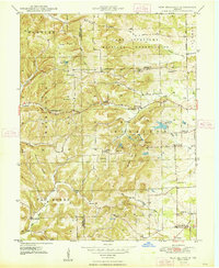 1948 New Bellsville1948 Print · USGSBartholomew and Brown County rural life and military expansion meet in the late 1940s. Genealogists and local historians can trace schoolhouse sites like Sprague Sch and family burial grounds including Dobbs Cem and Haislup Cem.
 - 1948 Map of Hope
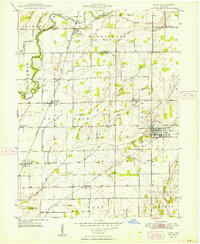 1948 Hope1948 Print · USGSBartholomew County enters the late 1940s as a thriving agricultural region defined by its rail junctions and numerous small settlements. Genealogists and historians can trace family locations through Moravian Cem, Flat Rock, and the unique dual sites of Old St Louis and St Louis Crossing.2 unique versions available
 - 1948 Map of Waymansville
 1948 Waymansville1948 Print · USGSBartholomew and Jackson counties appear here just after the war, showing a landscape of ridge-top schools and creek-bottom settlements. Researchers can trace the rural legacy of Waymansville and find local landmarks like Ohio Chapel, Taylor Chapel, and the St Paul Sch.2 unique versions available
 - 1948 Map of Nineveh
 1948 Nineveh1948 Print · USGSBartholomew and Johnson counties are captured here just after the war, when the landscape was defined by the massive Camp Atterbury Military Reservation. Genealogists and historians can trace the foundations of Nineveh and find significant sites like the Prisoner-of-War Cem and St Johns Ch.3 unique versions available
End of results
Showing maps 1-9 of 9
Top cities of Bartholomew County
- Columbus historical maps
- Hope historical maps
- Elizabethtown historical maps
- Hartsville historical maps
- Clifford historical maps
- Jonesville historical maps
Frequently asked questions
- What are the different types of historical maps available for Bartholomew County?
- What is the oldest map of Bartholomew County?
- Where can I purchase historical maps of Bartholomew County for my home or office?
- Where can I download high-res historical maps of Bartholomew County?
- Are there historical topographic maps available for Bartholomew County?
- Is there historical aerial imagery available for Bartholomew County?
- Where are historical maps of Bartholomew County sourced from?