1960s Maps of Bartholomew County, Indiana
Explore 8 historic maps of Bartholomew County from the 1960s. These maps offer a rare glimpse into what life looked like during the 1960s — showing old roads, neighborhoods, homes, and landmarks that have changed or disappeared over time.
Whether you're researching your family's past, planning a metal detecting trip, or studying how Bartholomew County's landscape evolved across the 1960s, these high-resolution maps are a powerful tool for exploring the history of this region.
- Focus on a specific era: All maps on this page are from the 1960s, giving you a focused view of this time period.
- See what’s changed: Compare century-old streets, trails, and buildings to today's modern landscape using overlays and satellite layers.
- Research with precision: Use these maps for genealogy, historical research, land use analysis, or educational projects.
- View, download, or print: Maps are fully viewable online in high resolution, and can be downloaded or printed for your own records.
Start exploring Bartholomew County's history through authentic maps from the 1960s. This is your window into the past.
Bartholomew County, IN maps
(8)- 1961 Map of Edinburg, 1964 Print
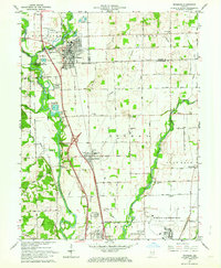 1961 Edinburg1964 Print · USGSThe river forks south of Indianapolis come alive in this early 1960s survey of the Driftwood and Flatrock valleys. Genealogists can locate family sites at Tannehill Cem and Old Bethel Ch, or trace the legacy of the Tannehill Covered Bridge.5 unique versions available
 - 1962 Map of Indianapolis
 1962 Indianapolis1962 Print · USGSCentral Indiana and the Illinois borderlands are captured here in the early sixties, showing the region's dense rail networks and growing urban centers. Genealogists and historians can locate family-named landmarks and institutions like Crown Hill Cem, Indiana University, and the Indianapolis Motor Speedway.
 - 1962 Map of New Bellsville, 1964 Print
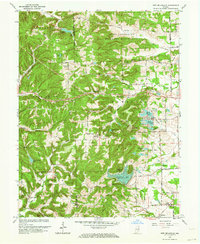 1962 New Bellsville1964 Print · USGSBartholomew County and the eastern edge of Brown County are shown in the early sixties as recreational lakes and military lands reshaped the rural landscape. Researchers can locate family cemeteries like Haislup Cem and Dobbs Cem, or trace early settlements from New Bellsville to Ogilville.5 unique versions available
 - 1962 Map of Nineveh, 1964 Print
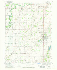
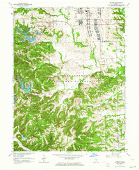 1962 Nineveh1964 Print · USGSSouth-central Indiana in the early sixties reveals a landscape transformed by defense and recreation. Trace local history through the Prisoner of War Camp, the residential growth at Princes Lakes, and the quiet grounds of Kansas Cem.4 unique versions available
 - 1962 Map of Waymansville, 1964 Print
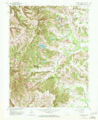 1962 Waymansville1964 Print · USGSBartholomew and Jackson counties meet in this early 1960s survey of the wooded ridges and creek bottoms south of Ogilville. Researchers can locate rural landmarks such as Waymansville, Ohio Chapel, and family burial sites like Weddell Cem and Gilmore Cem.6 unique versions available
 - 1962 Map of Columbus, 1964 Print
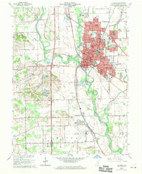 1962 Columbus1964 Print · USGSBartholomew County experiences a period of significant mid-century growth as the urban center of Columbus expands toward Bakalar Air Force Base. Genealogists and local historians can locate several family burial sites including Carter Cem and trace the path of the Pennsylvania railroad past Walesboro.6 unique versions available
 - 1962 Map of Jonesville, 1965 Print
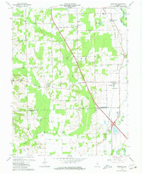 1962 Jonesville1965 Print · USGSBartholomew and Jackson Counties are captured in the early sixties as rural life centered on the river forks and the rail line. Genealogists can locate old homesteads near Walker Chapel, the Township Sch, and the riverside cluster at Little Acre.5 unique versions available
 - 1968 Map of Hope, 1970 Print
 1968 Hope1970 Print · USGSBartholomew and Shelby counties meet here in the late sixties, where the Flatrock River valley supports a network of rail-side towns and rural townships. Trace family roots at Old St Louis Cemetery or explore the settlements of Flat Rock and Hope.3 unique versions available
End of results
Showing maps 1-8 of 8
Top cities of Bartholomew County
- Columbus historical maps
- Hope historical maps
- Elizabethtown historical maps
- Hartsville historical maps
- Clifford historical maps
- Jonesville historical maps
Frequently asked questions
- What are the different types of historical maps available for Bartholomew County?
- What is the oldest map of Bartholomew County?
- Where can I purchase historical maps of Bartholomew County for my home or office?
- Where can I download high-res historical maps of Bartholomew County?
- Are there historical topographic maps available for Bartholomew County?
- Is there historical aerial imagery available for Bartholomew County?
- Where are historical maps of Bartholomew County sourced from?