1960s Maps of Dubois County, Indiana
Explore 10 historic maps of Dubois County from the 1960s. These maps offer a rare glimpse into what life looked like during the 1960s — showing old roads, neighborhoods, homes, and landmarks that have changed or disappeared over time.
Whether you're researching your family's past, planning a metal detecting trip, or studying how Dubois County's landscape evolved across the 1960s, these high-resolution maps are a powerful tool for exploring the history of this region.
- Focus on a specific era: All maps on this page are from the 1960s, giving you a focused view of this time period.
- See what’s changed: Compare century-old streets, trails, and buildings to today's modern landscape using overlays and satellite layers.
- Research with precision: Use these maps for genealogy, historical research, land use analysis, or educational projects.
- View, download, or print: Maps are fully viewable online in high resolution, and can be downloaded or printed for your own records.
Start exploring Dubois County's history through authentic maps from the 1960s. This is your window into the past.
Dubois County, IN maps
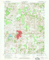
(10)- 1960 Map of Jasper, 1961 Print
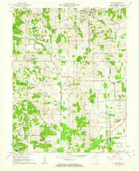
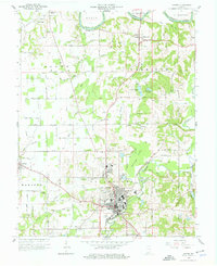 1960 Jasper1961 Print · USGSDubois County centered on Jasper shows a landscape of river-bend settlements and expanding rail infrastructure in the early sixties. Genealogists can locate family landmarks like Shiloh Ch and numerous rural plots including Alexander Cem and Wilhoit Cem.4 unique versions available
 - 1960 Map of Saint Meinrad, 1962 Print
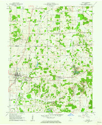
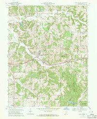
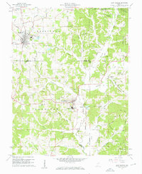 1960 Saint Meinrad1962 Print · USGSSouthern Indiana at the dawn of the sixties shows a unique mix of monastic tradition and coal production. Genealogists and historians can trace family-named landmarks like Tenn Beard Cem and Taylor Cem or locate the Saint Meinrad Seminary and its surrounding shrines.4 unique versions available
 - 1961 Map of Otwell, 1962 Print
 1961 Otwell1962 Print · USGSSouthern Indiana rural life is captured here in the early sixties, centered on the crossroads village of Otwell. Researchers can trace family history through numerous country landmarks like Traylor Union Ch, Chapel Cem, and the Otwell Holiness Camp.3 unique versions available
 - 1961 Map of Velpen, 1962 Print
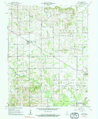
 1961 Velpen1962 Print · USGSThe border of Pike and Dubois counties comes alive in the early sixties as a landscape of timbered ridges, coal-country oil wells, and quiet hamlets. Genealogists and hikers can locate family landmarks like Stillwell Cem, the local Covered Bridge, and the community of Pikeville.2 unique versions available
 - 1961 Map of Holland, 1962 Print
 1961 Holland1962 Print · USGSThe crossroads of Dubois, Warrick, and Spencer counties come alive in the early sixties as rural life meets emerging industry. Researchers can trace the Old Indian Treaty Boundary and locate family burial sites like St James Cem or the Strip Mine near Selvin.3 unique versions available
 - 1961 Map of Dale, 1963 Print
 1961 Dale1963 Print · USGSSpencer and Dubois counties are shown here in the early sixties, a period when local industry and historical boundaries still defined the landscape. Researchers can trace family sites at Pinkston Cem, follow the old Indian Treaty Boundary, or locate the Strip Mine operations near Mariah Hill.2 unique versions available
 - 1965 Map of Hillham, 1966 Print
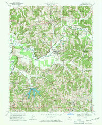
 1965 Hillham1966 Print · USGSSouthern Indiana's ridges and valleys are meticulously detailed in the mid-1960s as the Hoosier National Forest surrounds the Lost River. Genealogists and local historians can locate remote family sites like Anderson Cem and Hawkins Cem or trace the path of the Southern railroad through the Burton Tunnel.2 unique versions available
 - 1969 Map of Dubois, 1970 Print
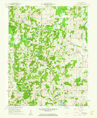
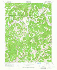
 1969 Dubois1970 Print · USGSSouthern Indiana in the late sixties reveals a landscape of river-valley agriculture and growing timber reserves. Genealogists and local researchers can trace family landmarks like Harbison Cem, Kellerville, and the numerous rural parish churches including St Peters Ch.3 unique versions available
 - 1969 Map of Huntingburg, 1971 Print
 1969 Huntingburg1971 Print · USGSHuntingburg and the surrounding Dubois County countryside are captured here in the late sixties, highlighting a period of local industrial and civic growth. Researchers can locate specific family sites like Main Cem and Hagen Cem or trace the old rail lines of the Southern railroad near Maltersville.3 unique versions available
 - 1969 Map of Saint Anthony, 1971 Print
 1969 Saint Anthony1971 Print · USGSDubois County in the late sixties shows a landscape of timbered hills and emerging recreation. Genealogists can trace family sites at Dugan Cem or Sacred Heart Sch while following the Southern railroad through Saint Marks.2 unique versions available
End of results
Showing maps 1-10 of 10
Top cities of Dubois County
Frequently asked questions
- What are the different types of historical maps available for Dubois County?
- What is the oldest map of Dubois County?
- Where can I purchase historical maps of Dubois County for my home or office?
- Where can I download high-res historical maps of Dubois County?
- Are there historical topographic maps available for Dubois County?
- Is there historical aerial imagery available for Dubois County?
- Where are historical maps of Dubois County sourced from?