1980s Maps of Dubois County, Indiana
Explore 6 historic maps of Dubois County from the 1980s. These maps offer a rare glimpse into what life looked like during the 1980s — showing old roads, neighborhoods, homes, and landmarks that have changed or disappeared over time.
Whether you're researching your family's past, planning a metal detecting trip, or studying how Dubois County's landscape evolved across the 1980s, these high-resolution maps are a powerful tool for exploring the history of this region.
- Focus on a specific era: All maps on this page are from the 1980s, giving you a focused view of this time period.
- See what’s changed: Compare century-old streets, trails, and buildings to today's modern landscape using overlays and satellite layers.
- Research with precision: Use these maps for genealogy, historical research, land use analysis, or educational projects.
- View, download, or print: Maps are fully viewable online in high resolution, and can be downloaded or printed for your own records.
Start exploring Dubois County's history through authentic maps from the 1980s. This is your window into the past.
Dubois County, IN maps
(6)- 1980 Map of Cuzco, 1981 Print
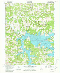 1980 Cuzco1981 Print · USGSOrange County's transition to a reservoir-centered landscape is clear in the early eighties as the new lake fills the valleys. Genealogists can trace the highlands around Cuzco and Crystal, finding landmarks like Cane Creek Ch and isolated rural Cem sites.2 unique versions available
 - 1980 Map of Birdseye, 1981 Print
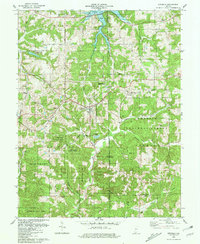 1980 Birdseye1981 Print · USGSBirdseye and the surrounding forest lands of southern Indiana are shown here just as the regional reservoir system reached into the valleys. Genealogists can trace family landmarks and rural burials at Waddle Cem, Spencer Cem, and Blunk Cem tucked among the hills.
 - 1986 Map of Bedford
 1986 Bedford1986 Print · USGSSouthern Indiana in the mid-eighties remains a landscape of deep forests, limestone quarries, and vital rail junctions. Genealogists and historians can trace the rural networks connecting French Lick, the Crane Naval Weapons Support Center, and the historic Becks Mill.
 - 1986 Map of Jasper
 1986 Jasper1986 Print · USGSSouthern Indiana in the 1980s is defined by the expansive Patoka Lake and the dense timber of the Hoosier National Forest. Researchers can trace the Southern RR through the hills or locate historic sites like Saint Meinrad and Sulphur Springs.
 - 1986 Map of Vincennes
 1986 Vincennes1986 Print · USGSThe Wabash River valley in the mid-1980s shows a landscape defined by deep-rooted river towns and heavy industry. Researchers can trace the legacy of regional rail lines like the Conrail system or locate landmarks such as Vincennes University and St Francisville Church.2 unique versions available
 - 1986 Map of Princeton
 1986 Princeton1986 Print · USGSSouthwestern Indiana is defined by the confluence of the Wabash and White Rivers during the mid-eighties, a period of established rail lines and expanding interstates. Genealogists and historians can trace property locations across numerous townships or locate family sites in Mount Carmel, Poseyville, and Boonville.2 unique versions available
End of results
Showing maps 1-6 of 6
Top cities of Dubois County
Frequently asked questions
- What are the different types of historical maps available for Dubois County?
- What is the oldest map of Dubois County?
- Where can I purchase historical maps of Dubois County for my home or office?
- Where can I download high-res historical maps of Dubois County?
- Are there historical topographic maps available for Dubois County?
- Is there historical aerial imagery available for Dubois County?
- Where are historical maps of Dubois County sourced from?