1900-1909 Maps of Dubois County, Indiana
Explore 6 historic maps of Dubois County from 1900-1909. These maps offer a rare glimpse into what life looked like during the 1900s — showing old roads, neighborhoods, homes, and landmarks that have changed or disappeared over time.
Whether you're researching your family's past, planning a metal detecting trip, or studying how Dubois County's landscape evolved across the 1900s, these high-resolution maps are a powerful tool for exploring the history of this region.
- Focus on a specific era: All maps on this page are from the 1900s, giving you a focused view of this time period.
- See what’s changed: Compare century-old streets, trails, and buildings to today's modern landscape using overlays and satellite layers.
- Research with precision: Use these maps for genealogy, historical research, land use analysis, or educational projects.
- View, download, or print: Maps are fully viewable online in high resolution, and can be downloaded or printed for your own records.
Start exploring Dubois County's history through authentic maps from the 1900s. This is your window into the past.
Dubois County, IN maps
(6)- 1900 Map of St Meinrad, 1961 Print
 1900 St Meinrad1961 Print · USGSSouthern Indiana at the turn of the century shows a landscape of growing rail towns and river crossings. Genealogists can trace family roots through early settlements like Santa Claus, St. Meinrad, and Mariah Hill, or locate landmarks such as Old Mill Fd.
 - 1900 Map of De Gonia Springs, 1963 Print
 1900 De Gonia Springs1963 Print · USGSSouthern Indiana at the turn of the century shows a landscape of rail-dependent towns and mineral spring resorts across Warrick and Spencer counties. Genealogists and historians can trace the early layouts of De Gonia Springs, Folsomville, and Tennyson along the SOUTHERN railroad lines.
 - 1902 Map of Ditney
 1902 Ditney1902 Print · USGSSouthern Indiana at the start of the century was a landscape of expanding railroads and rural hamlets. Family historians can trace ancestral roots through dozens of small settlements like Coats Springs, Dongola, and Boonville along the Southern RR.3 unique versions available
 - 1902 Map of Degonia Springs
 1902 Degonia Springs1902 Print · USGSSouthwestern Indiana is captured here at the turn of the century as the rail network linked the region's mineral springs and rural townships. Genealogists can trace the early layout of Degonia Springs, Folsomville, and Gentryville along the SOUTHERN railroad lines.2 unique versions available
 - 1903 Map of St. Meinrad
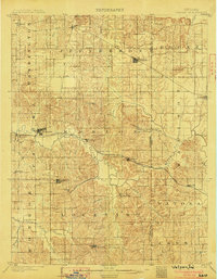
 1903 St. Meinrad1903 Print · USGSSouthern Indiana at the start of the twentieth century shows a landscape of rail-connected villages and the winding Anderson River. Trace the early routes of the Southern railway through Lincoln City or locate the original sites of Santa Claus and St.Meinrad.2 unique versions available
 - 1903 Map of Velpen
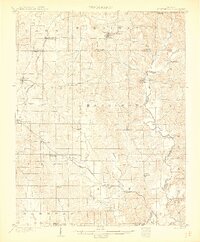
 1903 Velpen1903 Print · USGSSouthern Indiana at the start of the century was a landscape of river-bottom farms and emerging rail towns along the Patoka River. Genealogists and researchers can trace early township boundaries and find long-established communities like Winslow, Otwell, and the mineral waters of White Sulphur Springs.2 unique versions available
End of results
Showing maps 1-6 of 6
Top cities of Dubois County
Frequently asked questions
- What are the different types of historical maps available for Dubois County?
- What is the oldest map of Dubois County?
- Where can I purchase historical maps of Dubois County for my home or office?
- Where can I download high-res historical maps of Dubois County?
- Are there historical topographic maps available for Dubois County?
- Is there historical aerial imagery available for Dubois County?
- Where are historical maps of Dubois County sourced from?