1960s Maps of Veedersburg, Indiana
Explore 2 historic maps of Veedersburg from the 1960s. These maps offer a rare glimpse into what life looked like during the 1960s — showing old roads, neighborhoods, homes, and landmarks that have changed or disappeared over time.
Whether you're researching your family's past, planning a metal detecting trip, or studying how Veedersburg's landscape evolved across the 1960s, these high-resolution maps are a powerful tool for exploring the history of this region.
- Focus on a specific era: All maps on this page are from the 1960s, giving you a focused view of this time period.
- See what’s changed: Compare century-old streets, trails, and buildings to today's modern landscape using overlays and satellite layers.
- Research with precision: Use these maps for genealogy, historical research, land use analysis, or educational projects.
- View, download, or print: Maps are fully viewable online in high resolution, and can be downloaded or printed for your own records.
Start exploring Veedersburg's history through authentic maps from the 1960s. This is your window into the past.
Veedersburg, IN maps
(2)- 1962 Map of Hillsboro, 1964 Print
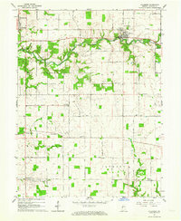 1962 Hillsboro1964 Print · USGSFountain County agriculture and transport intersect in the early sixties as the New York Central railroad serves rural townships. Genealogists and local historians can locate several rural burial grounds and churches, including Rose Hill Cemetery and Scotts Prairie Ch.2 unique versions available
 - 1967 Map of Veedersburg, 1968 Print
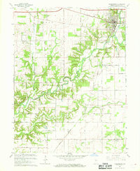 1967 Veedersburg1968 Print · USGSFountain County life in the late sixties centers on the rail-and-creek network surrounding Veedersburg. Researchers can trace rural school sites like Rabb Sch and several country churches, including Snoddy Ch and Prairie Creek Ch.
End of results
Showing maps 1-2 of 2
Top cities near Veedersburg
- Attica historical maps
- Covington historical maps
- Eugene historical maps
- Williamsport historical maps
- Cayuga historical maps
- Waynetown historical maps
See more
Frequently asked questions
- What are the different types of historical maps available for Veedersburg?
- What is the oldest map of Veedersburg?
- Where can I purchase historical maps of Veedersburg for my home or office?
- Where can I download high-res historical maps of Veedersburg?
- Are there historical topographic maps available for Veedersburg?
- Is there historical aerial imagery available for Veedersburg?
- Where are historical maps of Veedersburg sourced from?