1960s Maps of Jackson County, Indiana
Explore 8 historic maps of Jackson County from the 1960s. These maps offer a rare glimpse into what life looked like during the 1960s — showing old roads, neighborhoods, homes, and landmarks that have changed or disappeared over time.
Whether you're researching your family's past, planning a metal detecting trip, or studying how Jackson County's landscape evolved across the 1960s, these high-resolution maps are a powerful tool for exploring the history of this region.
- Focus on a specific era: All maps on this page are from the 1960s, giving you a focused view of this time period.
- See what’s changed: Compare century-old streets, trails, and buildings to today's modern landscape using overlays and satellite layers.
- Research with precision: Use these maps for genealogy, historical research, land use analysis, or educational projects.
- View, download, or print: Maps are fully viewable online in high resolution, and can be downloaded or printed for your own records.
Start exploring Jackson County's history through authentic maps from the 1960s. This is your window into the past.
Jackson County, IN maps
(8)- 1960 Map of Scottsburg, 1961 Print
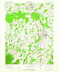 1960 Scottsburg1961 Print · USGSScottsburg and Austin are mapped here at the dawn of the sixties, highlighting the region's rail-dependent growth and rural agricultural network. Genealogists and historians can trace family locations near Mt Zion Church, Leota, and the My Pleasant Cemetery.5 unique versions available
 - 1962 Map of Indianapolis
 1962 Indianapolis1962 Print · USGSCentral Indiana and the Illinois borderlands are captured here in the early sixties, showing the region's dense rail networks and growing urban centers. Genealogists and historians can locate family-named landmarks and institutions like Crown Hill Cem, Indiana University, and the Indianapolis Motor Speedway.
 - 1962 Map of Waymansville, 1964 Print
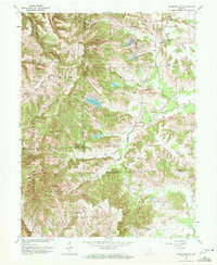 1962 Waymansville1964 Print · USGSBartholomew and Jackson counties meet in this early 1960s survey of the wooded ridges and creek bottoms south of Ogilville. Researchers can locate rural landmarks such as Waymansville, Ohio Chapel, and family burial sites like Weddell Cem and Gilmore Cem.6 unique versions available
 - 1962 Map of Jonesville, 1965 Print
 1962 Jonesville1965 Print · USGSBartholomew and Jackson Counties are captured in the early sixties as rural life centered on the river forks and the rail line. Genealogists can locate old homesteads near Walker Chapel, the Township Sch, and the riverside cluster at Little Acre.5 unique versions available
 - 1964 Map of Louisville
 1964 Louisville1964 Print · USGSThe Ohio River valley and Kentucky Bluegrass are captured in the mid-1960s, showing a region balanced between industrial growth and its agrarian roots. Genealogists and historians can trace the development of county seats like Shelbyville and Paris, or locate established institutions such as Georgetown College and Bernheim Forest.
 - 1966 Map of Elkinsville, 1968 Print
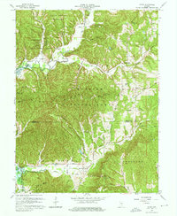
 1966 Elkinsville1968 Print · USGSSouthern Indiana's hills were undergoing a major transformation in the mid-sixties as the new reservoir began to reshape the valley floor. Genealogists can trace family footprints at Elkinsville Cem or Terril Cem, and find the remote Hunter Creek Ch deep in the woods.4 unique versions available
 - 1967 Map of Story, 1968 Print
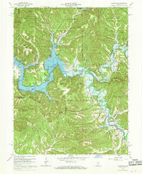
 1967 Story1968 Print · USGSBrown and Jackson counties are shown in the late sixties as the rising waters of Monroe Lake began to alter the valley floor. Genealogists can trace family names and early boundaries through the Old Indian Treaty Boundary and sites like Moffitt Cem or Elkinsville.7 unique versions available
 - 1968 Map of Crothersville, 1970 Print
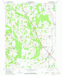
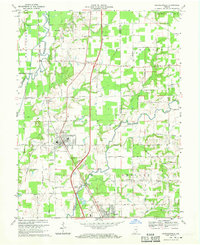 1968 Crothersville1970 Print · USGSSoutheastern Indiana during the late sixties shows a landscape of small towns and rail-connected farms. Genealogists can trace family landmarks like Wesley Chapel, Crothersville Cem, and the old settlement at Uniontown along the Penn Central line.2 unique versions available
End of results
Showing maps 1-8 of 8
Top cities of Jackson County
- Seymour historical maps
- Brownstown historical maps
- Crothersville historical maps
- Medora historical maps
Frequently asked questions
- What are the different types of historical maps available for Jackson County?
- What is the oldest map of Jackson County?
- Where can I purchase historical maps of Jackson County for my home or office?
- Where can I download high-res historical maps of Jackson County?
- Are there historical topographic maps available for Jackson County?
- Is there historical aerial imagery available for Jackson County?
- Where are historical maps of Jackson County sourced from?