1940s Maps of Jackson County, Indiana
Explore 5 historic maps of Jackson County from the 1940s. These maps offer a rare glimpse into what life looked like during the 1940s — showing old roads, neighborhoods, homes, and landmarks that have changed or disappeared over time.
Whether you're researching your family's past, planning a metal detecting trip, or studying how Jackson County's landscape evolved across the 1940s, these high-resolution maps are a powerful tool for exploring the history of this region.
- Focus on a specific era: All maps on this page are from the 1940s, giving you a focused view of this time period.
- See what’s changed: Compare century-old streets, trails, and buildings to today's modern landscape using overlays and satellite layers.
- Research with precision: Use these maps for genealogy, historical research, land use analysis, or educational projects.
- View, download, or print: Maps are fully viewable online in high resolution, and can be downloaded or printed for your own records.
Start exploring Jackson County's history through authentic maps from the 1940s. This is your window into the past.
Jackson County, IN maps
(5)- 1942 Map of Franklin
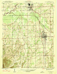
 1942 Franklin1942 Print · USGSCentral Indiana during the early years of the war shows a landscape of established rail towns and growing military installations. Genealogists can trace family names across small settlements like Nineveh, Bean Blossom, and Helmsburg, or locate the Indiana University Observatory.
 - 1942 Map of Columbus
 1942 Columbus1942 Print · USGSBartholomew and Shelby counties are shown during the early years of the war, as military installations and rail lines reshaped the rural Indiana landscape. Genealogists can trace family-named sites and established communities like St Louis Crossing, Hope, and the sprawling Camp Atterbury.
 - 1947 Map of Scottsburg
 1947 Scottsburg1947 Print · USGSScott County’s agricultural and rail corridor is meticulously detailed shortly after the war, centered on the growing hubs of Scottsburg and Austin. Genealogists can locate family landmarks such as New Providence Ch, Carlisle Sch, and the COUNTY FARM.2 unique versions available
 - 1947 Map of Elkinsville, 1961 Print
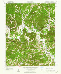 1947 Elkinsville1961 Print · USGSBrown County and Monroe County are captured just after the war, showing the rural way of life along the forks of Salt Creek. Researchers can trace the layout of Elkinsville and Maumee, locating old landmarks like Chambers Bridge and Bethel Ch.
 - 1948 Map of Waymansville
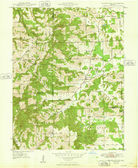 1948 Waymansville1948 Print · USGSBartholomew and Jackson counties appear here just after the war, showing a landscape of ridge-top schools and creek-bottom settlements. Researchers can trace the rural legacy of Waymansville and find local landmarks like Ohio Chapel, Taylor Chapel, and the St Paul Sch.2 unique versions available
End of results
Showing maps 1-5 of 5
Top cities of Jackson County
- Seymour historical maps
- Brownstown historical maps
- Crothersville historical maps
- Medora historical maps
Frequently asked questions
- What are the different types of historical maps available for Jackson County?
- What is the oldest map of Jackson County?
- Where can I purchase historical maps of Jackson County for my home or office?
- Where can I download high-res historical maps of Jackson County?
- Are there historical topographic maps available for Jackson County?
- Is there historical aerial imagery available for Jackson County?
- Where are historical maps of Jackson County sourced from?