1960s Maps of Jay County, Indiana
Explore 12 historic maps of Jay County from the 1960s. These maps offer a rare glimpse into what life looked like during the 1960s — showing old roads, neighborhoods, homes, and landmarks that have changed or disappeared over time.
Whether you're researching your family's past, planning a metal detecting trip, or studying how Jay County's landscape evolved across the 1960s, these high-resolution maps are a powerful tool for exploring the history of this region.
- Focus on a specific era: All maps on this page are from the 1960s, giving you a focused view of this time period.
- See what’s changed: Compare century-old streets, trails, and buildings to today's modern landscape using overlays and satellite layers.
- Research with precision: Use these maps for genealogy, historical research, land use analysis, or educational projects.
- View, download, or print: Maps are fully viewable online in high resolution, and can be downloaded or printed for your own records.
Start exploring Jay County's history through authentic maps from the 1960s. This is your window into the past.
Jay County, IN maps
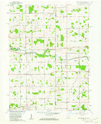
(12)- 1960 Map of Pennville, 1961 Print
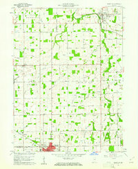 1960 Pennville1961 Print · USGSIndiana's eastern farmland is documented here in the early sixties, showing the vital rail and river networks of Jay and Blackford counties. Researchers can locate family landmarks like Maple Lawn Cem, the crossroads of Ridertown, and the Pennsylvania Railroad corridor.2 unique versions available
 - 1960 Map of Fort Recovery, 1961 Print
 1960 Fort Recovery1961 Print · USGSThe Indiana-Ohio borderlands come into focus during the early sixties, centered on the historic village of Fort Recovery. Genealogists and historians can trace the Old Indian Treaty Road and locate numerous family burial grounds like Old Pioneer Cem and Limber Cem.2 unique versions available
 - 1960 Map of Blaine, 1961 Print
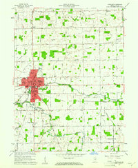
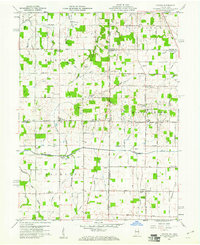
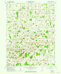
 1960 Blaine1961 Print · USGSJay County's rural townships are shown here during a period of steady mid-century growth along the river and rail lines. Genealogists and researchers can trace family-named sites like Whiteman Cem, visit country landmarks like Sugar Grove Ch, or locate the old Drive-in Theater.3 unique versions available
 - 1960 Map of Portland, 1961 Print
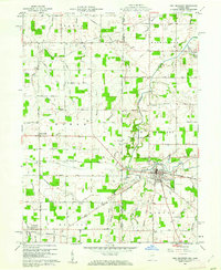
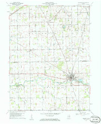
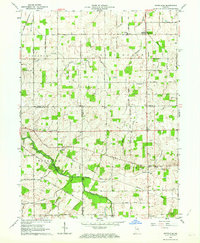
 1960 Portland1961 Print · USGSThe Jay County seat of Portland is shown in the early sixties as a thriving rail hub and agricultural center. Local historians can trace the legacy of neighborhood schools like Haynes Sch and Lincoln Sch or locate family sites near Liber Cem.2 unique versions available
 - 1960 Map of Cosmos, 1961 Print
 1960 Cosmos1961 Print · USGSThe Indiana-Ohio borderlands at the start of the sixties were a grid of productive farmland and small rural parishes. Researchers can trace ancestral sites and local landmarks like Salem, Raper Chapel, and Mt Zion Cem Ch across the state line.4 unique versions available
 - 1960 Map of Ridgeville, 1961 Print
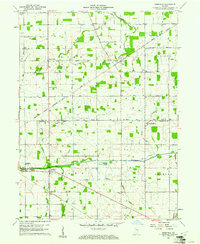
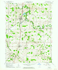
 1960 Ridgeville1961 Print · USGSEast-central Indiana is captured here at the start of the sixties, showing a landscape defined by the Mississinewa River and rail lines. Genealogists can locate family sites at Odd Fellows Cem and Powers Cem or trace the early Indian Treaty Boundary.3 unique versions available
 - 1960 Map of Deerfield, 1961 Print
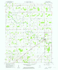
 1960 Deerfield1961 Print · USGSRandolph and Jay counties appear here in the early sixties, a landscape defined by the Old Indian Treaty Boundary and the winding Mississinewa River. Genealogists can locate several historic burial sites like Lawn Dale Cem, Neimer Cem, and the community of New Pittsburg.
 - 1960 Map of Redkey, 1962 Print
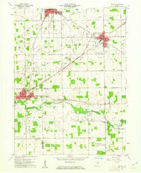 1960 Redkey1962 Print · USGSEastern Indiana in the early sixties shows a landscape where industrial rail hubs meet the agricultural heartland. Genealogists and local historians can trace family roots through sites like Cherry Grove Sch, Shedville, and the Strong Cem near the Mississinewa River.2 unique versions available
 - 1960 Map of New Corydon, 1962 Print
 1960 New Corydon1962 Print · USGSThe Indiana-Ohio borderlands come to life in this early 1960s survey of the Wabash River valley. Genealogists and researchers can trace family roots through numerous country landmarks like Jefferson Sch, Liberty Cem, and the small community of New Corydon.3 unique versions available
 - 1962 Map of Petroleum, 1964 Print
 1962 Petroleum1964 Print · USGSEast-central Indiana's rural landscape is captured here in the early sixties, showing the intersection of three counties along the Salamonie River. Researchers can trace old property lines and community landmarks like Petroleum Sch, Gilead Ch, and the namesake Oil Wells of the region.
 - 1962 Map of Geneva, 1964 Print
 1962 Geneva1964 Print · USGSNortheast Indiana in the early sixties reveals a landscape of drainage-fed farmland and literary history near the Ohio border. Trace the legacy of Gene Stratton-Porter at the Limberlost State Memorial or locate family plots at Gravel Hill Cem and Snow Cem.2 unique versions available
 - 1962 Map of Domestic, 1964 Print
 1962 Domestic1964 Print · USGSIndiana’s borderlands between Wells, Adams, and Jay Counties are mapped here in the early sixties as agricultural drainage transformed the landscape. Genealogists can trace family sites at Alberson Cemetery or locate old schoolhouses like Township School near Poling.
End of results
Showing maps 1-12 of 12
Top cities of Jay County
- Portland historical maps
- Redkey historical maps
- Greene historical maps
- Pennville historical maps
- Noble historical maps
- Bryant historical maps
See more
Frequently asked questions
- What are the different types of historical maps available for Jay County?
- What is the oldest map of Jay County?
- Where can I purchase historical maps of Jay County for my home or office?
- Where can I download high-res historical maps of Jay County?
- Are there historical topographic maps available for Jay County?
- Is there historical aerial imagery available for Jay County?
- Where are historical maps of Jay County sourced from?