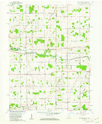
1960 Map of New Corydon
USGS Topo · Published 1962About this map
The Wabash River meanders through this borderland landscape between Indiana and Ohio, anchoring the settlements of New Corydon and Jay City. The area is characterized by a dense network of early rural roads, including Skeels Road and Frahm Pike, which connect isolated farmsteads and local landmarks. Genealogists will find a wealth of data in the numerous religious and educational sites scattered across the townships, such as Mt Carmel Ch, St Marys Ch, and Jefferson Sch. Further south, the map documents the Limberlost region and the headwaters of Limberlost Creek, a name deeply tied to Indiana literary and natural history. Significant industrial markers like several Gravel Pit operations and a series of Oil Wells indicate the extraction economy of the mid-20th century. Local history is further preserved through small rural hamlets like Trinity, Padua, and Skeels Crossroads, alongside several dedicated burial grounds including Liberty Cem and the State Line Cem.
Find a feature on this map
51 named features on this map. Tap any name to fly to it.
Don’t see what you’re looking for? This feature index may not catch every label — zoom into the map to look around manually.
Map Details
Editions of this 1960 New Corydon Map
Other maps of this area

1908 · St. Henry
USGS Topo · 1:62,500

1911 · Berne
USGS Topo · 1:48,000

1914 · Celina
USGS Topo · 1:62,500

1915 · Fort Recovery
USGS Topo · 1:48,000

1918 · Fort Recovery
USGS Topo · 1:62,500

1944 · Celina
USGS Topo · 1:62,500

1953 · Muncie
USGS Topo · 1:250,000

1956 · Muncie
USGS Topo · 1:250,000

1960 · Fort Recovery
USGS Topo · 1:24,000
1960 · Erastus
USGS Topo · 1:24,000