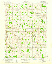
1960 Map of Erastus
USGS Topo · Published 1961About this map
Agricultural lands and rural townships define this 1960 survey of Mercer County, Ohio, capturing the landscape before the heavy modernization of rural infrastructure. The terrain is crisscrossed by family-named roads like Oregon Road and Frahm Pike, connecting small settlements such as Erastus and Durbin. A network of watercourses including Beaver Creek and the Wabash River drains the region, while the presence of several Oil Wells and a Settling Pit near Beaver Chapel suggests localized petroleum extraction. Local social life is anchored by numerous country churches, such as St Pauls Ch and Mt Carmel Ch, and the uniquely named Swamp College school. The map provides a detailed view of property divisions and the early pipeline network cutting across Hopewell and Jefferson townships, making it an essential resource for tracing 20th-century family homesteads.
Find a feature on this map
55 named features on this map. Tap any name to fly to it.
Don’t see what you’re looking for? This feature index may not catch every label — zoom into the map to look around manually.
Map Details
Editions of this 1960 Erastus Map
2 editions found
Other maps of this area

1908 · St. Henry
USGS Topo · 1:62,500

1911 · Berne
USGS Topo · 1:48,000

1914 · Celina
USGS Topo · 1:62,500

1915 · Fort Recovery
USGS Topo · 1:48,000

1918 · Fort Recovery
USGS Topo · 1:62,500

1944 · Celina
USGS Topo · 1:62,500

1953 · Muncie
USGS Topo · 1:250,000

1956 · Muncie
USGS Topo · 1:250,000

1960 · Fort Recovery
USGS Topo · 1:24,000
1960 · Celina
USGS Topo · 1:24,000