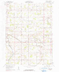
1960 Map of Erastus
USGS Topo · Published 1990About this map
The crossroads of Erastus and Hinton anchor this agricultural landscape in Mercer County, where early 1960s rural life centered on a dense network of country roads and family-named homesteads. The terrain is defined by the headwaters of Beaver Creek and Black Creek, which wind through the townships of Liberty and Hopewell. This survey reveals a persistent religious and community infrastructure, including Friends Home Ch and Beaver Chapel, alongside evocative local burial grounds like Swamp College Cem and Landfair Ch Cem. Evidence of mid-century extractive industry is scattered across the sheet, particularly in the form of multiple Oil Wells and a Quarry north of Durbin. The grid of roads, such as Mud Pike and Oregon Road, illustrates the rectilinear land division common in western Ohio, providing a clear reference for genealogical and land-use research in this region.
Find a feature on this map
56 named features on this map. Tap any name to fly to it.
Don’t see what you’re looking for? This feature index may not catch every label — zoom into the map to look around manually.
Map Details
Editions of this 1960 Erastus Map
2 editions found
Other maps of this area

1908 · St. Henry
USGS Topo · 1:62,500

1911 · Berne
USGS Topo · 1:48,000

1914 · Celina
USGS Topo · 1:62,500

1915 · Fort Recovery
USGS Topo · 1:48,000

1918 · Fort Recovery
USGS Topo · 1:62,500

1944 · Celina
USGS Topo · 1:62,500

1953 · Muncie
USGS Topo · 1:250,000

1956 · Muncie
USGS Topo · 1:250,000

1960 · Fort Recovery
USGS Topo · 1:24,000
1960 · Celina
USGS Topo · 1:24,000