1900s (20th Century) Maps of Macy, Indiana
Explore 7 historic maps of Macy from the 1900s (20th Century). These maps offer a rare glimpse into what life looked like during the 1900s — showing old roads, neighborhoods, homes, and landmarks that have changed or disappeared over time.
Whether you're researching your family's past, planning a metal detecting trip, or studying how Macy's landscape evolved across the 1900s, these high-resolution maps are a powerful tool for exploring the history of this region.
- Focus on a specific era: All maps on this page are from the 1900s, giving you a focused view of this time period.
- See what’s changed: Compare century-old streets, trails, and buildings to today's modern landscape using overlays and satellite layers.
- Research with precision: Use these maps for genealogy, historical research, land use analysis, or educational projects.
- View, download, or print: Maps are fully viewable online in high resolution, and can be downloaded or printed for your own records.
Start exploring Macy's history through authentic maps from the 1900s. This is your window into the past.
Macy, IN maps
(7)- 1953 Map of Danville, 1965 Print
 1953 Danville1965 Print · USGSIndiana and Illinois crossroads come to life in this mid-century survey as the interstate era begins to reshape the river-and-rail landscape. Genealogists and collectors can trace the historic paths of the Nickel Plate railroad or locate smaller communities like Veedersburg, Goodland, and Bismarck.3 unique versions available
 - 1955 Map of Danville
 1955 Danville1955 Print · USGSThe Indiana-Illinois borderlands during the mid-fifties reveal a landscape of thriving rail hubs and university towns. Researchers can trace the legacy of Purdue University, the Tippecanoe Battlefield, and the path of the Pennsylvania RR.
 - 1956 Map of Danville
 1956 Danville1956 Print · USGSMid-century Indiana and Illinois are captured here as the river-and-rail economy evolved into the modern highway era. Researchers can trace ancestral roots and old transport lines through Logansport, Battle Ground, and the dams at Lake Shafer.
 - 1960 Map of Macy, 1963 Print
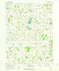 1960 Macy1963 Print · USGSMiami and Fulton counties are captured here in the early 1960s, a period when the rural landscape was defined by its railroad crossings and small townships. Researchers can trace the junction of two major lines at Macy or locate ancestral sites like Mud Lake Chapel and Plainview Cemetery.3 unique versions available
 - 1960 Map of Deedsville, 1963 Print
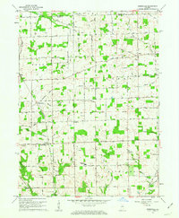 1960 Deedsville1963 Print · USGSMiami County, Indiana, is captured at the dawn of the 1960s, showing a rural landscape defined by the Old Indian Treaty Boundary and the Chicago and St Louis RR. Genealogists and local historians can trace the foundations of Deedsville and find scattered landmarks like Ebenezer Ch and Yike Cem.2 unique versions available
 - 1985 Map of Logansport
 1985 Logansport1985 Print · USGSNorth-central Indiana in the mid-eighties shows a landscape of river-fed towns and significant military aviation hubs. Genealogists and local historians can trace the rail corridors of the Conrail or locate sites like River View Cem and the crossroads at Twelve Mile.2 unique versions available
 - 1992 Map of Deedsville, 1995 Print
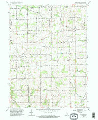 1992 Deedsville1995 Print · USGSMiami and Fulton counties remained deeply agricultural in the 1990s, with this survey showing the small-town life around Deedsville and Macy. Genealogists can locate family burial grounds including Tilden Cem and Musselman Cem near the Ebenezer Ch.
End of results
Showing maps 1-7 of 7
Top cities near Macy
- Logansport historical maps
- Peru historical maps
- Rochester historical maps
- Walnut historical maps
- Akron historical maps
- Mentone historical maps
See more
Frequently asked questions
- What are the different types of historical maps available for Macy?
- What is the oldest map of Macy?
- Where can I purchase historical maps of Macy for my home or office?
- Where can I download high-res historical maps of Macy?
- Are there historical topographic maps available for Macy?
- Is there historical aerial imagery available for Macy?
- Where are historical maps of Macy sourced from?