2020s Maps of Crawfordsville, Indiana
Explore 2 historic maps of Crawfordsville from the 2020s. These maps offer a rare glimpse into what life looked like during the 2020s — showing old roads, neighborhoods, homes, and landmarks that have changed or disappeared over time.
Whether you're researching your family's past, planning a metal detecting trip, or studying how Crawfordsville's landscape evolved across the 2020s, these high-resolution maps are a powerful tool for exploring the history of this region.
- Focus on a specific era: All maps on this page are from the 2020s, giving you a focused view of this time period.
- See what’s changed: Compare century-old streets, trails, and buildings to today's modern landscape using overlays and satellite layers.
- Research with precision: Use these maps for genealogy, historical research, land use analysis, or educational projects.
- View, download, or print: Maps are fully viewable online in high resolution, and can be downloaded or printed for your own records.
Start exploring Crawfordsville's history through authentic maps from the 2020s. This is your window into the past.
Crawfordsville, IN maps
(2)- 2022 Map of Crawfordsville, 2022 Print
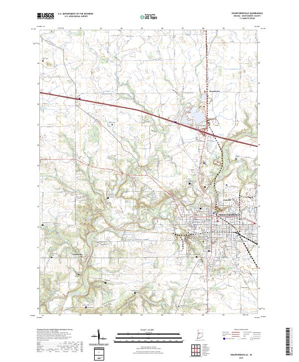 2022 Crawfordsville2022 Print · USGSCrawfordsville and the surrounding Montgomery County countryside are documented here in the early twenty-first century, centered on the historic Wabash College campus. Researchers can trace numerous family burial sites such as Harshbarger Cemetery and Stover Cemetery along the banks of Sugar Creek.
 - 2022 Map of Darlington, 2022 Print
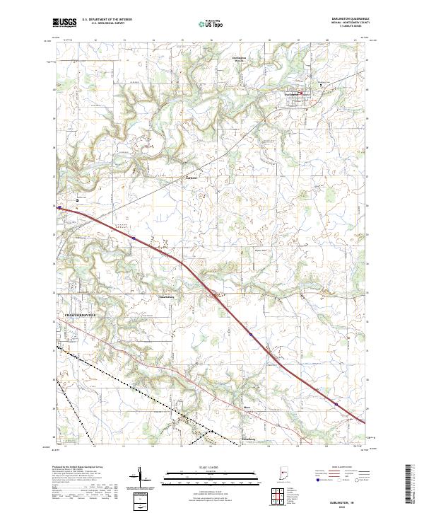 2022 Darlington2022 Print · USGSMontgomery County farmland in the early 2020s is defined by the winding Sugar Creek and the busy corridor of Interstate 74. Genealogists and local researchers can locate Greenlawn Cem and trace the small crossroads of Mace and Smartsburg.
End of results
Showing maps 1-2 of 2
Top cities near Crawfordsville
- Ladoga historical maps
- Roachdale historical maps
- Waynetown historical maps
- Darlington historical maps
- Colfax historical maps
- Linden historical maps
See more
Top neighborhoods of Crawfordsville
Frequently asked questions
- What are the different types of historical maps available for Crawfordsville?
- What is the oldest map of Crawfordsville?
- Where can I purchase historical maps of Crawfordsville for my home or office?
- Where can I download high-res historical maps of Crawfordsville?
- Are there historical topographic maps available for Crawfordsville?
- Is there historical aerial imagery available for Crawfordsville?
- Where are historical maps of Crawfordsville sourced from?