1940s Maps of Orange County, Indiana
Explore 4 historic maps of Orange County from the 1940s. These maps offer a rare glimpse into what life looked like during the 1940s — showing old roads, neighborhoods, homes, and landmarks that have changed or disappeared over time.
Whether you're researching your family's past, planning a metal detecting trip, or studying how Orange County's landscape evolved across the 1940s, these high-resolution maps are a powerful tool for exploring the history of this region.
- Focus on a specific era: All maps on this page are from the 1940s, giving you a focused view of this time period.
- See what’s changed: Compare century-old streets, trails, and buildings to today's modern landscape using overlays and satellite layers.
- Research with precision: Use these maps for genealogy, historical research, land use analysis, or educational projects.
- View, download, or print: Maps are fully viewable online in high resolution, and can be downloaded or printed for your own records.
Start exploring Orange County's history through authentic maps from the 1940s. This is your window into the past.
Orange County, IN maps
(4)- 1947 Map of Hardinsburg, 1966 Print
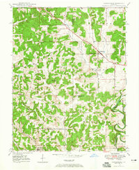 1947 Hardinsburg1966 Print · USGSSouthern Indiana's rural landscape is captured here in the late 1940s, showing a patchwork of small farms and family-named creek crossings. Genealogists can trace family roots at Oak Grove Ch, Walton Cem, and early schools like School No 6.
 - 1948 Map of Huron, 1960 Print
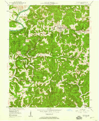 1948 Huron1960 Print · USGSMartin County in the late 1940s is characterized by its deep forest tracts and the busy rail line through the village of Huron. Researchers can trace early rural life through surviving landmarks like Scarlet Chapel, Wiesbach Sch, and the Baltimore and Ohio railroad.
 - 1949 Map of Hardinsburg
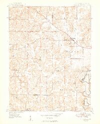 1949 Hardinsburg1949 Print · USGSSouthern Indiana at the end of the 1940s reveals a patchwork of rural school districts and county-line settlements. Genealogists can trace family footprints across Hardinsburg and Marengo or find ancestral sites like Old Unity Cem and Baptist Hill Ch.2 unique versions available
 - 1949 Map of Georgia, 1962 Print
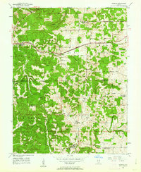 1949 Georgia1962 Print · USGSThe rural borders of Lawrence and Orange Counties come alive in this post-war survey of a landscape shaped by the Baltimore and Ohio railroad. Local researchers can trace family roots through the many country churches and schools like Bonds Chapel, Georgia Ch, and the Hindostan Sch.
End of results
Showing maps 1-4 of 4
Top cities of Orange County
- Paoli historical maps
- Orleans historical maps
- French Lick historical maps
- Stampers Creek historical maps
- Orangeville historical maps
- West Baden Springs historical maps
Frequently asked questions
- What are the different types of historical maps available for Orange County?
- What is the oldest map of Orange County?
- Where can I purchase historical maps of Orange County for my home or office?
- Where can I download high-res historical maps of Orange County?
- Are there historical topographic maps available for Orange County?
- Is there historical aerial imagery available for Orange County?
- Where are historical maps of Orange County sourced from?