1980s Maps of Orange County, Indiana
Explore 4 historic maps of Orange County from the 1980s. These maps offer a rare glimpse into what life looked like during the 1980s — showing old roads, neighborhoods, homes, and landmarks that have changed or disappeared over time.
Whether you're researching your family's past, planning a metal detecting trip, or studying how Orange County's landscape evolved across the 1980s, these high-resolution maps are a powerful tool for exploring the history of this region.
- Focus on a specific era: All maps on this page are from the 1980s, giving you a focused view of this time period.
- See what’s changed: Compare century-old streets, trails, and buildings to today's modern landscape using overlays and satellite layers.
- Research with precision: Use these maps for genealogy, historical research, land use analysis, or educational projects.
- View, download, or print: Maps are fully viewable online in high resolution, and can be downloaded or printed for your own records.
Start exploring Orange County's history through authentic maps from the 1980s. This is your window into the past.
Orange County, IN maps
(4)- 1980 Map of Greenbrier
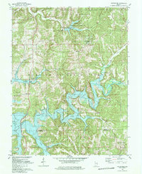 1980 Greenbrier1980 Print · USGSSouthern Indiana was undergoing a dramatic transformation in the late seventies as the newly created Patoka Lake filled the deep wooded valleys. Genealogists and local historians can trace old road networks and find quiet landmarks like South Liberty Ch, McDougal Ch, and the settlement of Greenbrier.3 unique versions available
 - 1980 Map of Cuzco, 1981 Print
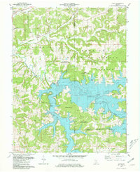 1980 Cuzco1981 Print · USGSOrange County's transition to a reservoir-centered landscape is clear in the early eighties as the new lake fills the valleys. Genealogists can trace the highlands around Cuzco and Crystal, finding landmarks like Cane Creek Ch and isolated rural Cem sites.2 unique versions available
 - 1986 Map of Bedford
 1986 Bedford1986 Print · USGSSouthern Indiana in the mid-eighties remains a landscape of deep forests, limestone quarries, and vital rail junctions. Genealogists and historians can trace the rural networks connecting French Lick, the Crane Naval Weapons Support Center, and the historic Becks Mill.
 - 1986 Map of Jasper
 1986 Jasper1986 Print · USGSSouthern Indiana in the 1980s is defined by the expansive Patoka Lake and the dense timber of the Hoosier National Forest. Researchers can trace the Southern RR through the hills or locate historic sites like Saint Meinrad and Sulphur Springs.
End of results
Showing maps 1-4 of 4
Top cities of Orange County
- Paoli historical maps
- Orleans historical maps
- French Lick historical maps
- Stampers Creek historical maps
- Orangeville historical maps
- West Baden Springs historical maps
Frequently asked questions
- What are the different types of historical maps available for Orange County?
- What is the oldest map of Orange County?
- Where can I purchase historical maps of Orange County for my home or office?
- Where can I download high-res historical maps of Orange County?
- Are there historical topographic maps available for Orange County?
- Is there historical aerial imagery available for Orange County?
- Where are historical maps of Orange County sourced from?